"Old" Flora lake trail - ClubTread Community

User Tag List

 
LinkBack Thread Tools
post #1 of (permalink) Old 09-01-2012, 05:34 PM Thread Starter
Banned
 
Join Date: Sep 2004
Location: Chwk, , Canada.
Posts: 5,318
Default "Old" Flora lake trail

Was up at Chwk Lake today...looking for the old Flora T/H and I think I might have found it:


Only problem is that it was basically heading AWAY (in dark BLUE on the map) from the newer trail. I suppose it could swing back towards the North eventually, but there's that big gorge between the two.
So...was I close, or did I miss completely?


LOTS of people at the Lindeman parking area!


TheShadow is offline  
Quote
Sponsored Links
Advertisement
 
post #2 of (permalink) Old 09-01-2012, 06:10 PM
High on the Mountain Top
 
Join Date: Sep 2008
Location: Fraser Valley
Interest: Photography, Nature Observation, Health & Fitness, Nutrition, Shinrin-yoku
Posts: 1,730
Default

When I was living in the Lower Mainland, I use to hike up and down that trail quite often. It starts down the chwk lake road where there is a road cut of soft sand. The trail is quite steep and runs along a bluff at one point before joining up with the existing trail.
solo75 is offline  
post #3 of (permalink) Old 09-01-2012, 06:24 PM
Headed for the Mountains
 
Join Date: May 2010
Location: chilliwack, bc, Canada.
Interest: Hiking, running and geocaching
Posts: 198
Default

I have a waypoint at about 1600 metres on your side of the ravine confirming what solo75 said about the trails joining up.
mhzman is offline  
Sponsored Links
Advertisement
 
post #4 of (permalink) Old 09-01-2012, 06:45 PM
High on the Mountain Top
 
Kanike's Avatar
 
Join Date: Aug 2008
Location: Chilliwack
Interest: hiking, biking, running, kayaking, scrambling, snowshoeing, backpacking and ice-skating.
Posts: 1,610
Default

I was up there yesterday and what solo said is correct. Check out my photos on fb.

Kanike is offline  
post #5 of (permalink) Old 09-01-2012, 07:11 PM
Headed for the Mountains
 
giverhard's Avatar
 
Join Date: Feb 2010
Location: Chilliwack, B.C., Canada.
Posts: 402
Default

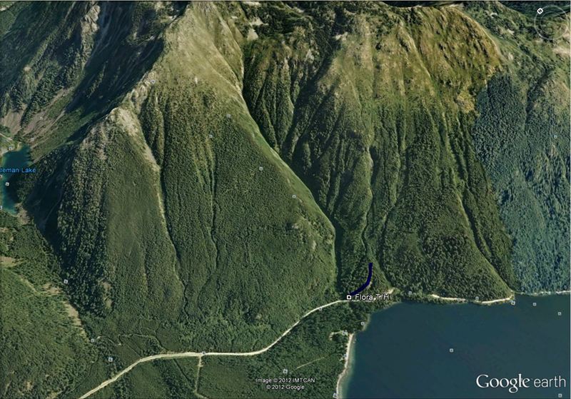
No, you found it, what you have highlighted is the ancient, oldest of the trails. (you round a bend in the road and it's just after a creek on the left taking off in an Easterly direction. Very established foot base, but overgrown and un used)

The trail the others speak of links up with the current Flora route and is about 500m before the one Shadow posted about. I was asking about the same trail a few weeks ago but got no info, so did some more wandering and learned this.

That old trail will take you right to alpine staying on the East side of that gorge, never once dose it connect up with the current route. I am inclined to believe it crests the pass in between Flora-East peak and the un-named peak between it and Paleface, as I have seen the remnants of the trail heading down the valley to Flora lake, between the Flora-Paleface ridge and Wittenburg. We turned back in the avalanche chutes just below alpine, but it was still well marked, though very overgrown. Also MASSIVE piles of bear scat were seen, made us wonder about grizzly.

The other old (newer) trail is fairly short and links up with the current trail, it was probably abandoned because of the grade and lack of parking with the Lindeman/Greendrop TH so close by.
giverhard is offline  
post #6 of (permalink) Old 09-01-2012, 07:35 PM Thread Starter
Banned
 
Join Date: Sep 2004
Location: Chwk, , Canada.
Posts: 5,318
Default

Here are some photos I took of the first portion of the trail:


And coming back down:


The red squares lead me to believe this is indeed an older trail. The fact that it is on the wrong side of the ravine, leads me to believe Giverhard's appraisal.
This was located in a righthand curve in the road, right beside a stream.

So where does the newer of the "old" ones start? The one that connects to the "newer" trail (from Lindeman parking area)?


TheShadow is offline  
post #7 of (permalink) Old 09-01-2012, 08:11 PM
Headed for the Mountains
 
giverhard's Avatar
 
Join Date: Feb 2010
Location: Chilliwack, B.C., Canada.
Posts: 402
Default

That's the oldest one for sure. Like I said, I followed it up to where I was breaking out of trees into sub alpine. Dosn't ever meet the new (current) trail. Wish I'd had my gps along that trip to record it, but alas. It's quite a steep trail, but nowhere near as steep as it could be. Alot of manpower was put into it in it's hay-day, cut right into the hill side in places doing short switch backs. Once you get up a bit, it follows that smaller ravine (you can see it in your Google Earth map, just to the right of your blue line) and zig zags back and forth across it. That smaller ravine is clearly a frequent avalanche path.

Here I drew very roughly where the trail goes as far as I went.

The newer Old trail is just past the very last power pole, also on the left. About 100ft past.
It spits you onto the current Flora trail about 2 km up roughly. Just before the first lookout.
giverhard is offline  
post #8 of (permalink) Old 09-02-2012, 03:01 AM
Summit Master
 
Join Date: Jan 2005
Location: , , Canada.
Interest: Hiking, hunting, fishing, and many others.
Posts: 3,951
Default

The old trail that meets the new one does come out on a sandy looking spur road on the Chilliwack Lake road as solo75 said and in the location giverhard said. The very old trail started out going to a mining claim and then became the original route to Flora Lake where it goes down the ravine on it's south end.

That approach later changed when the new trail was done to the top of the saddle where it now drops down to Flora Lake. Instead of dropping down to the lake where it does now the newer trail followed the ridge on the west side of Flora Lake and went down that ravine to the south end of the lake.

The very old original trail can be seen going down the mountain from that col going to the ravine.


Wildman is offline  
post #9 of (permalink) Old 09-02-2012, 07:44 AM
Headed for the Mountains
 
giverhard's Avatar
 
Join Date: Feb 2010
Location: Chilliwack, B.C., Canada.
Posts: 402
Default

Thanks for the additional info Wildman. Those pictures actually put it perfectly into perspective as I can recognize some of the features I could see where I turned back at.
Have you ever done the old trail in it's entirety?
Also, have you been up the valley much this summer? I keep my eyes peeled for your little honda anytime I find myself back in there. lol Hope all's well
giverhard is offline  
post #10 of (permalink) Old 09-02-2012, 01:29 PM
Summit Master
 
Join Date: Jan 2005
Location: , , Canada.
Interest: Hiking, hunting, fishing, and many others.
Posts: 3,951
Default

Quote:
quote:Originally posted by giverhard

Thanks for the additional info Wildman. Those pictures actually put it perfectly into perspective as I can recognize some of the features I could see where I turned back at.
Have you ever done the old trail in it's entirety?
Also, have you been up the valley much this summer? I keep my eyes peeled for your little honda anytime I find myself back in there. lol Hope all's well
No I have never done that whole leg. Would be interesting and may try it some day.
I have been back there fairly often this year.
Come visit when you get a chance.
Wildman is offline  
Reply

Thread Tools
Show Printable Version Show Printable Version
Email this Page Email this Page


Posting Rules  
You may not post new threads
You may not post replies
You may not post attachments
You may not edit your posts

BB code is On
Smilies are On
[IMG] code is On
HTML code is Off
Trackbacks are On
Pingbacks are On
Refbacks are On

 
For the best viewing experience please update your browser to Google Chrome
 

Search Engine Optimization by vBSEO 3.6.1