Chain Lakes & Table Mountain Sept.18/16 - ClubTread Community

User Tag List

 3Likes
  • 1 Post By KARVITK
  • 2 Post By KARVITK
 
LinkBack Thread Tools
post #1 of (permalink) Old 09-21-2016, 11:18 PM Thread Starter
Super Moderator
 
KARVITK's Avatar
 
Join Date: Apr 2005
Location: Abbotsford, B.C., Canada.
Interest: Hiking, Snowshoeing, and Photography. Enjoying the outdoors fresh air and fitness experience.
Posts: 17,917
Default Chain Lakes & Table Mountain Sept.18/16

This hike was one of our scheduled Ridge Meadows Outdoor hikes I set up and volunteered to Lead. There were four of us who took part in this trip; Ziff, Wil, KJ, and myself. Thank you all for coming to make this a fine day. Rain was in the forecast, but this improved........and actually the day was totally dry for our hike, and we got a fair bit of sunshine amongst the clouds and table top fog.

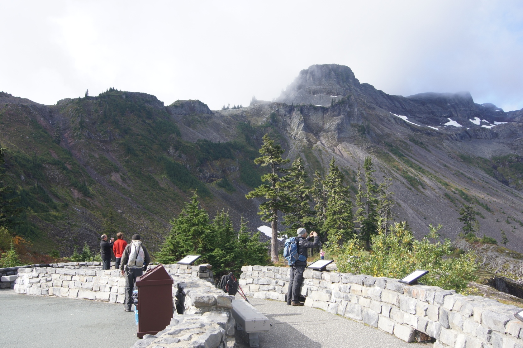
Abbotsford was the starting point around 7:30 am; and ended up starting the hike after 10 am; on our way we had a stop at the lookout (Austin Pass) near the visitor center. To enjoy the beauty of the meadows, Table Mountain, etc.

From the Artist Point Parking Lot; we hiked down the Wild Goose Trail to return to the lookout and just pass by the information center; over the stone bridge spanning the creek draining the largest of the Baglie Lakes.. and then westward towards the pass Table Mountain - Mt. Herman

It was that kind of day where three of us took hundreds of pictures.... so limited to adding a few here.

Stats: chain Lake loop, 280 meters elevation loss from the parking lot, gained 360 meters to the pass overlooking Iceberg Lake, then drop 200 meters and regain less than 100 to return along the south of Table Mountain. 12 km return., 5 hours return including lunch and many stops, plus 1/2 hour wasted to run back and retrieve my forgotten GPS.

Stats: Table Mountain, 130 meters elevation gained quickly and then a further 80 meters more to the summit of Table Mountain at its west end. 4 km return - 1 & 1/2 hours.

PHOTOS - CHAIN LAKES LOOP

The small tarn before you get to the Visitor Center


TRAIL Route MAP


View to distant Mountain, adjacent to pass overlooking Iceberg lake, and Visitor Center lower right.
This is where hike to ..on way down from Artist Point


The Viewpoint


Lower, smaller Baglie Lakes Chain


Pleasant trail, meadow below the Visitor Center


The Stone Bridge & Its Arches


Crossing this bridge


Trademark "Mt. Baker Wilderness" sign


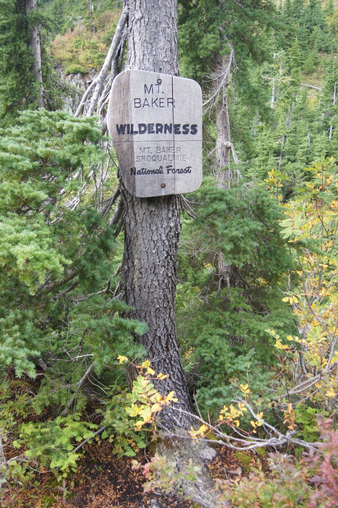
Table Mountain - its northern ridge extension


View of Iceberg Lake from that high pass


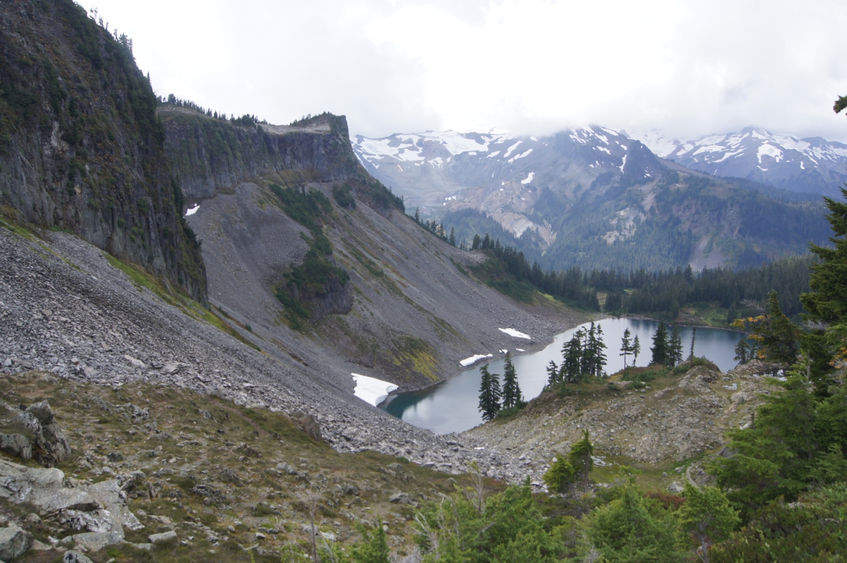
Iceberg lake @ foot of the Table Mountain (NW corner)


Open Meadow above the lake, and the view of the Iceberg lake


Hayes Lake nearby, to the north by 100 meters


ICEBERG LAKE as viewed from its SW Shore


Mazama Lakes and adjacent camping ground area


Table Mountain NW corner high point viewed from west perimter trail beyond the lakes


Interesting - columnar & hexagonal basalt rock formation


Trail skirting south of Table Mountain


Rock formation shaped like bleacher steps, or a Roman Amphitheatre


From here... we headed back to the parking lot for a brief stop, leaving most of our gear in the vehicle. I switched from my heavy pack to a light pack, and onward to Table Mountain we go.
Attached Thumbnails
Click image for larger version

Name:	DSC00985.JPG
Views:	1350
Size:	766.6 KB
ID:	179089  

Click image for larger version

Name:	DSC00987.JPG
Views:	406
Size:	1.06 MB
ID:	179097  

Click image for larger version

Name:	DSC00988.JPG
Views:	360
Size:	1.01 MB
ID:	179105  

Click image for larger version

Name:	DSC01000.JPG
Views:	364
Size:	807.9 KB
ID:	179113  

Click image for larger version

Name:	DSC01004.JPG
Views:	355
Size:	887.5 KB
ID:	179121  

Click image for larger version

Name:	DSC01006.JPG
Views:	372
Size:	1.08 MB
ID:	179129  

Click image for larger version

Name:	DSC01011.JPG
Views:	348
Size:	938.9 KB
ID:	179137  

Click image for larger version

Name:	DSC01013.JPG
Views:	360
Size:	979.0 KB
ID:	179145  

Click image for larger version

Name:	DSC01026.JPG
Views:	342
Size:	1.17 MB
ID:	179153  

Click image for larger version

Name:	DSC01029.JPG
Views:	366
Size:	1,012.7 KB
ID:	179161  

Click image for larger version

Name:	DSC01043.JPG
Views:	341
Size:	721.2 KB
ID:	179169  

Click image for larger version

Name:	DSC01048.JPG
Views:	348
Size:	921.2 KB
ID:	179177  

Click image for larger version

Name:	DSC01055.JPG
Views:	332
Size:	1.02 MB
ID:	179185  

Click image for larger version

Name:	DSC01062.JPG
Views:	400
Size:	1.05 MB
ID:	179193  

Click image for larger version

Name:	DSC01068.JPG
Views:	335
Size:	873.5 KB
ID:	179201  

Click image for larger version

Name:	DSC01082.JPG
Views:	344
Size:	1.03 MB
ID:	179209  

Click image for larger version

Name:	DSC01083.JPG
Views:	354
Size:	1.03 MB
ID:	179217  

Click image for larger version

Name:	DSC01084.JPG
Views:	338
Size:	895.8 KB
ID:	179225  

Click image for larger version

Name:	DSC01088.JPG
Views:	339
Size:	1.18 MB
ID:	179233  

Click image for larger version

Name:	DSC01092.JPG
Views:	324
Size:	1.09 MB
ID:	179241  

Click image for larger version

Name:	DSC01100.JPG
Views:	347
Size:	953.0 KB
ID:	179249  

sixer likes this.

Hiking is what keeps you young of mind and heart. When the going gets tough, the tough get going..............

Last edited by KARVITK; 09-21-2016 at 11:46 PM.
KARVITK is offline  
Quote
Sponsored Links
Advertisement
 
post #2 of (permalink) Old 09-21-2016, 11:23 PM Thread Starter
Super Moderator
 
KARVITK's Avatar
 
Join Date: Apr 2005
Location: Abbotsford, B.C., Canada.
Interest: Hiking, Snowshoeing, and Photography. Enjoying the outdoors fresh air and fitness experience.
Posts: 17,917
Default TABLE MOUNTAIN HIKE, 2nd of the Day

Photos of ascent to Table Mountain, and exploration of its plateau.

Table Mountain well visited by old and young alike...


Forest we trek through to Table Mountain


Trail Steps of columnar basaltic rock


Ascending the steep trail, wide path


Great retaining wall


Great view of Artist Point, Parking Lot


Top of Cliff look down to part of Baglie Lake


A glassy Tarn in the rim-forest meadow


View down to lower slopes below Table Mountain, behind the trees


Forest on Table Mountain, like a strip on the rim


View South, west to Mtn where Ptmarigan Trail starts


General lay of terrain; rock talus rubble


One of many snow fields still present


Zoom view to Coleman Pinnacle


NW Corner of Table Mountain, plus near top - tarns


Attached Thumbnails
Click image for larger version

Name:	102_5061.JPG
Views:	357
Size:	465.9 KB
ID:	179257  

Click image for larger version

Name:	102_5062.JPG
Views:	352
Size:	467.3 KB
ID:	179265  

Click image for larger version

Name:	102_5063.JPG
Views:	364
Size:	707.2 KB
ID:	179273  

Click image for larger version

Name:	102_5068.JPG
Views:	321
Size:	460.3 KB
ID:	179281  

Click image for larger version

Name:	102_5073.JPG
Views:	317
Size:	577.7 KB
ID:	179289  

Click image for larger version

Name:	DSC01118.JPG
Views:	344
Size:	904.0 KB
ID:	179297  

Click image for larger version

Name:	DSC01119.JPG
Views:	327
Size:	830.8 KB
ID:	179305  

Click image for larger version

Name:	DSC01109.JPG
Views:	343
Size:	871.5 KB
ID:	179313  

Click image for larger version

Name:	102_5083.JPG
Views:	350
Size:	397.5 KB
ID:	179321  

Click image for larger version

Name:	102_5085.JPG
Views:	355
Size:	489.9 KB
ID:	179329  

Click image for larger version

Name:	DSC01107.JPG
Views:	326
Size:	789.1 KB
ID:	179337  

Click image for larger version

Name:	102_5086.JPG
Views:	335
Size:	488.4 KB
ID:	179345  

Click image for larger version

Name:	DSC01105.JPG
Views:	343
Size:	666.6 KB
ID:	179353  

Click image for larger version

Name:	102_5087.JPG
Views:	304
Size:	225.1 KB
ID:	179361  

Click image for larger version

Name:	102_5091.JPG
Views:	320
Size:	447.1 KB
ID:	179369  

outdoors guy and Crash like this.

Hiking is what keeps you young of mind and heart. When the going gets tough, the tough get going..............

Last edited by KARVITK; 09-21-2016 at 11:31 PM.
KARVITK is offline  
post #3 of (permalink) Old 10-04-2016, 08:40 PM
High on the Mountain Top
 
xj6response's Avatar
 
Join Date: Jul 2010
Location: Sunshine Coast, BC, Canada.
Posts: 2,319
Default

we just spent a few days at Glacier doing the same trails, in the fog, rain and wind ... oh well, fun day anyway ... on Sunday we just ambled around Artists Ridge and ptarmigan ridge in the brilliant sunshine. Got a lovely shot of Shuksan. Looks like a fun group you hike with.
Attached Thumbnails
Click image for larger version

Name:	20161002_121850.jpg
Views:	99
Size:	438.3 KB
ID:	182233  


________________________________

Last edited by xj6response; 10-04-2016 at 08:52 PM. Reason: spelling
xj6response is online now  
Sponsored Links
Advertisement
 
post #4 of (permalink) Old 10-06-2016, 12:29 AM Thread Starter
Super Moderator
 
KARVITK's Avatar
 
Join Date: Apr 2005
Location: Abbotsford, B.C., Canada.
Interest: Hiking, Snowshoeing, and Photography. Enjoying the outdoors fresh air and fitness experience.
Posts: 17,917
Default

Quote:
Originally Posted by xj6response View Post
we just spent a few days at Glacier doing the same trails, in the fog, rain and wind ... oh well, fun day anyway ... on Sunday we just ambled around Artists Ridge and ptarmigan ridge in the brilliant sunshine. Got a lovely shot of Shuksan. Looks like a fun group you hike with.
Beautiful picture. Looks like you got the hike in on a really beautiful day.

K

Hiking is what keeps you young of mind and heart. When the going gets tough, the tough get going..............
KARVITK is offline  
Reply

Thread Tools
Show Printable Version Show Printable Version
Email this Page Email this Page


Posting Rules  
You may not post new threads
You may not post replies
You may not post attachments
You may not edit your posts

BB code is On
Smilies are On
[IMG] code is On
HTML code is Off
Trackbacks are On
Pingbacks are On
Refbacks are On

 
For the best viewing experience please update your browser to Google Chrome
 

Search Engine Optimization by vBSEO 3.6.1