Montserrat, Caribbean, Oriele Trail, Feb 2012 - ClubTread Community

User Tag List

 
LinkBack Thread Tools
post #1 of (permalink) Old 06-09-2013, 10:33 PM Thread Starter
High on the Mountain Top
 
dougz's Avatar
 
Join Date: Mar 2010
Location: Mackenzie, BC, Canada.
Interest: hiking, skiing, camping, SAR, Canadian Rangers (army reserve)
Posts: 1,515
Default Montserrat, Caribbean, Oriele Trail, Feb 2012

Looking at Longshadow's and Rachelo's tropical TR's has me thinking back whistfully on my trip to Montserrat back in Feb of 2012..

So, sorry if this is too late for a TR, but I don't think trail conditions will have changed much, even if the active volcano erupts again(!), as the trail I reference is outside the Exclusion Zone (the area volcanologists have agreed is the furthest range of lethal fall-out from an eruption).

http://www.youtube.com/watch?v=GeghNYm_03A


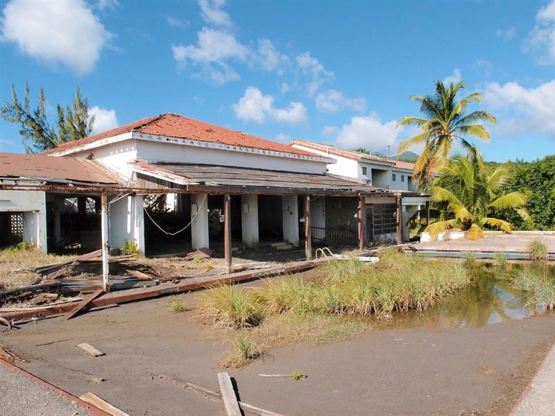
(the grey area in the middle right is what's left of Montserrat's former capital, which was destroyed by pyroclastic lava flows in 1995).

Last time the volcano erupted was in 2006(very minor, compared to the major one where people were killed was in '95), but there are frequent ash clouds from small eruptions that dump a fine film over everything every once in a while.

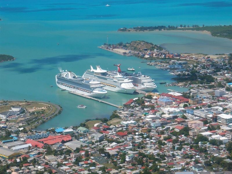
Montserrat is in the Caribbean Leeward Isles chain, just off of Antigua.


There is quite a variety of terrain for such a small island (16 X 11 km), from lush Mesic Forest in the southern lowlands


to the truly 'wet' Littoral forest and Elfin Woodland jungle in the upper mountains.


and then just a few km to the north is the quite arid and windblown 'dry' tropical forest to the north (God's backside, as the islander's call it).


Then of course there's the area to the south affected by the lava and mud flows:


Anyways, on to the TR. This TR is regarding the Oriele Trail, named after Montserrat's national bird, which can be seen on this hike (though it's said only when you have a guide, and he can 'call' them).

We got up and headed out from the excellent villa we stayed at:


at around 10am. The weather was a bit overcast, but of course very warm and humid (+20C abouts). It actually started coming down pretty good as we made it to the trailhead.


But I'm glad I didn't give in to my wife's pleas to turn back, as it let up within 20 minutes, and we were dry again very quickly (we didn't bring any rain gear, as with the humidity we would have been as soaked with sweat as we would have been with rain), and the sun made an appearance here and there.


Soursop fruit (thanks, qiz!)

Not sure what this is..

We found the trail head after a few false starts, and started upwards.


It got quite muddy very quickly, and there were a few very small streamlets to hop over.


The canopy was very thick


and so there wasn't much for views despite the elevation until we came to the crest of a hill at the apex of the trail, where there was a small clearing and you could look around.


Nearing the end of the trail the trees thinned out a bit as we entered a dry river bed and there were these cool hardwoods with lots of vines, etc.


But all good things must come to an end:


We covered 6.4km in 3 hours, including the rest break at the viewing area.


Time for a nice beer


And a dip!


I was quite freaked out about sharks, so didn't go in for very long..


Advantages going in Feb: dryer, no mosquitoes, -20C back home!

Disadvantages: No mangoes (they're in summer), not as warm (relatively speaking!).

Who needs a signature? Mine is always: Last edited by dougz; Today at 03:27 PM
dougz is offline  
Quote
Sponsored Links
Advertisement
 
post #2 of (permalink) Old 06-10-2013, 07:18 AM
Summit Master
 
Join Date: Oct 2001
Location: Langley, BC, Canada.
Interest: Hiking, backpacking, snowshoeing, photography, computers, yoga and traveling.
Posts: 7,689
Default

Nice place! Funny when looking at the size of the island compared to the rest of the chain. Enjoyed your TR. The local beer at the end looked refreshing too.


LongShadow is offline  
post #3 of (permalink) Old 06-10-2013, 08:28 AM
Super Moderator
 
Join Date: Mar 2005
Location: Calgary, Alberta, Andorra.
Interest: hiking, backpacking, scrambling, climbing
Posts: 4,437
Default

That's really interesting! You can't get anywhere near the volcano area?

Awesome jungles.
Rachelo is offline  
Sponsored Links
Advertisement
 
post #4 of (permalink) Old 06-10-2013, 08:37 AM
Summit Master
 
Join Date: Oct 2001
Location: Langley, BC, Canada.
Interest: Hiking, backpacking, snowshoeing, photography, computers, yoga and traveling.
Posts: 7,689
Default

BTW, curious about what was in the jungles (if anything). I know on Hawaii there isn't much to be concerned about. Wild boars and roosters. And of course the giant bees.


LongShadow is offline  
post #5 of (permalink) Old 06-10-2013, 09:30 AM Thread Starter
High on the Mountain Top
 
dougz's Avatar
 
Join Date: Mar 2010
Location: Mackenzie, BC, Canada.
Interest: hiking, skiing, camping, SAR, Canadian Rangers (army reserve)
Posts: 1,515
Default

Quote:
quote:Funny when looking at the size of the island compared to the rest of the chain. Enjoyed your TR. The local beer at the end looked refreshing too.
Yup, I think it's THE smallest of them. Got a few square km bigger in the last big eruption in '95..


All that beach at the top left is from the lava flow of that eruption..

The beer WAS good, but it's hard to be objective after a hike..

Definitely welcome.. LOL

Quote:
quote:That's really interesting! You can't get anywhere near the volcano area?
There's an exclusion zone that you need to sign in at a gate to enter, and if you're not a native, you need to be with a guide.

The nearest we got on land (with a guide, by car, which is left running) was the hotel pool in the very first photo, which was 4km away. Some guides will take you closer than others...

Red dot is where we were (red dot in sea is where we got on boat tour)

Here's a live cam of the volcano from the Observatory (6km away):

http://www.mvo.ms/science/monitoring...cano-live/1718

If it starts to rain, you need to book, like yesterday, as there's a risk of 'lahars' - flash floods of ash, that can cut you off from the other side of roads, etc.

http://www.youtube.com/watch?v=Z4wIJLAY6x0

And of course there's a risk of an eruption (even with an observatory keeping constant watch you might only get a few minutes warning).

The danger isn't the actual magma flow, which travels really slowly (unlike lava from volcanoes in Hawaii, for example). The danger is in the ash and superheated air (1000C), which travels around 700 km/h.

By sea you can go a little closer ($50 each for a tour) to Plymouth, as you are only about 50m from shore. Probably about the same distance from the volcano, though..


The Montserratians work right in Plymouth (in the exclusion zone, obviously) around the old pier. They load ash with heavy machinery onto a barge and tug it out to a concrete factory on the other side of the island. It's pretty much the only industry on the island. They also truck it out. It's risky, but they're pretty desperate for work, and they can be out by boat or by truck within 5-6 minutes.

Quote:
quote:curious about what was in the jungles (if anything)
There are no large indigenous mammals on Montserrat, just small pigs (not boar, exactly, no huge tusks) that were introduced from Europe and have gone feral, domesticated goats (they just run free everywhere, and everyone knows which goat is theirs).

There is a large rodent called an agouti that was introduced from S. America (related to guinea pigs) that is all over the place, eating out people's gardens. Harmless.. About the size of a cat. Tend to be in groups of 3-4.

http://en.wikipedia.org/wiki/Common_agouti


Don't think there are any rats, though.

Several species of bats.. Large iguanas and other lizards.

And there are large frogs,Leptodactylus fallax, that used to be eaten regularly (they're nick-named 'mountain chicken'), but now they're more-or-less a protected species.

http://en.wikipedia.org/wiki/Leptodactylus_fallax

No poisonous spiders except tarantula in the upper, upper mountains.. No poisonous snakes at all. No poisonous insects.

HUGE spiders (size of a fricken hand!) that hang around the banana trees, look like facehuggers from Aliens, but aren't poisonous. We saw one next to our night stand one night (they like to come inside when the wind picks up), and that was the end of the open windows! I was screaming like a girl while Svetlana shooed it outside with a broom...
dougz is offline  
post #6 of (permalink) Old 06-10-2013, 10:44 AM
Headed for the Mountains
 
Join Date: Jun 2007
Location: Calgary, AB, Canada.
Posts: 387
Default

Nice seeing Montserrat from the ground. My wife and I honeymooned in Antigua and I splurged for her first heli ride over to Montserrat. Pretty awesome to see the the interior of the island completely buried by ash and lahars. The former capital, Plymouth had some nice looking villas... from the chopper it looked very post-apocalyptic. One of my favorite memories was seeing steam venting through a series of burned out sugar mills.

Cheers,

C
caurala is offline  
post #7 of (permalink) Old 06-10-2013, 10:58 AM
Super Moderator
 
KARVITK's Avatar
 
Join Date: Apr 2005
Location: Abbotsford, B.C., Canada.
Interest: Hiking, Snowshoeing, and Photography. Enjoying the outdoors fresh air and fitness experience.
Posts: 17,917
Default

Thank you for a very interesting read, this is one of my favourite TR's, I felt I was experiencing your travels and views through this island. Amazing how such a small island can have so much variety in landform, vegetation..... it looks a lot bigger.

K
KARVITK is offline  
post #8 of (permalink) Old 06-10-2013, 11:04 AM Thread Starter
High on the Mountain Top
 
dougz's Avatar
 
Join Date: Mar 2010
Location: Mackenzie, BC, Canada.
Interest: hiking, skiing, camping, SAR, Canadian Rangers (army reserve)
Posts: 1,515
Default

Quote:
quote:My wife and I honeymooned in Antigua and I splurged for her first heli ride over to Montserrat
You used to be able to get to Montserrat via helicopter as well.

Now it's just by plane (6 seater), $120 one way out of Antigua, or by ferry (out of Antigua as well).

Antigua looks very nice from the air..


Nice beaches, more night life (in Montserrat everything shuts down by around 4, except for the bars and dance halls, which we aren't into).

But I'm told the mosquitoes are much worse there.

Lots of crime, also. Montserrat is famously the friendliest of all the Caribbean Islands.. We left our door unlocked, on the word of the owners of the villa, expat Americans who have been there 30+ years). But obviously that also has to do with Montserrat's population of 3,000 (everyone pretty much knows everyone) vs. 89,000 in Antigua.

Bad potable water in Antigua, I'm told as well (Montserrat actually exports their water, which they get from a natural spring).

Big advantage in Montserrat is there are no tourists (maybe 20 on the whole island at any one time). So you have whole beaches to yourselves (there's 2 black sand beaches, and one white sand beach).


And also it's ridiculously cheap in comparison to Antigua and the other islands.

You can get a villa for $120 Cdn a night!

There's maybe 100 Ex pats from the UK (the island is a UK Protectorate), and a few from the States and Canada. They are the owners of the villas, almost exclusively. Then there's the UK Volconologists at the Observatory (10, maybe?).

Disadvantages: No night life (like I say, not a big deal with us), lack of shops, restaurants, etc. No real hospital. The diving is ok, but not great (from what I'm told).

And it's a small island, so once you've been there for more than a couple days, you've pretty much done that, you know?

If I was going to go back to the Caribbean, I'd like to go to Dominica, which has good hikes, I'm told. Crime is bad, there, though.. bars on your windows, bad..

Quote:
quote:Thank you for a very interesting read, this is one of my favourite TR's
Thanks! My pleasure..

Quote:
quote:Amazing how such a small island can have so much variety in landform, vegetation..... it looks a lot bigger.
Here are some shots from the air, to give you some perspective:

North East

North

North West
dougz is offline  
post #9 of (permalink) Old 06-10-2013, 02:07 PM
Super Moderator
 
KARVITK's Avatar
 
Join Date: Apr 2005
Location: Abbotsford, B.C., Canada.
Interest: Hiking, Snowshoeing, and Photography. Enjoying the outdoors fresh air and fitness experience.
Posts: 17,917
Default

Thanks Doug. Looks fairly hill from those angles.

K
KARVITK is offline  
post #10 of (permalink) Old 06-10-2013, 03:07 PM Thread Starter
High on the Mountain Top
 
dougz's Avatar
 
Join Date: Mar 2010
Location: Mackenzie, BC, Canada.
Interest: hiking, skiing, camping, SAR, Canadian Rangers (army reserve)
Posts: 1,515
Default

Quote:
quote:Looks fairly hill from those angles
There are 3 major groups of hills (2 dormant volcanoes and the active one)..


The hills in the center (Katy Hill) are where the Oriele trail goes.. There are trails that go higher up, but are treacherous because of the much denser vegetation (Elfin Woodland) and steep ridge lines. I wanted to go on one, but it was $200 US for a guide, and I didn't feel comfortable with just a GPS, and tarantulas creep me out!

So I went for a hike to the North end with some people from the UK (2 volcanologists and a music teacher volunteering at the local school), which is easily accessible, and an interesting change in terrain and vegetation.

Pretty much all the flat, arable land is in the valley between Katy Hill and the Souffeire Hills (the volcano), but it's uninhabitable now (in the exclusion zone), so they have to make due with the hillsides for their limited farming capabilities.


EVERYTHING is at some incline or another..

We did about 5 hikes all together, not including walking all over the island's inhabited areas (sometimes 10km a day). The roads were too winding and steep, and you're driving on the opposite side, UK style.. So I wasn't comfortable renting a car, even though it meant 6km walk to the beaches and other areas we wanted to check out (we hitched a ride occasionally, but mostly just hoofed it).


My wife was not happy with me..

But I told her it meant these were guilt-free!


And then there was one..
dougz is offline  
post #11 of (permalink) Old 06-13-2013, 05:49 AM
qiz
Headed for the Mountains
 
Join Date: Jul 2008
Location: , , .
Posts: 100
Default

The first mystery fruit in your TR is soursop (Annona muricata) http://en.wikipedia.org/wiki/Soursop
When I was in Thailand we saw it being grown in commercial orchards.
Can't help with the 2nd mystery fruit!
qiz is offline  
post #12 of (permalink) Old 06-13-2013, 05:56 AM
qiz
Headed for the Mountains
 
Join Date: Jul 2008
Location: , , .
Posts: 100
Default

D'oh! not Thailand, Mexico!!
qiz is offline  
post #13 of (permalink) Old 06-13-2013, 07:21 AM Thread Starter
High on the Mountain Top
 
dougz's Avatar
 
Join Date: Mar 2010
Location: Mackenzie, BC, Canada.
Interest: hiking, skiing, camping, SAR, Canadian Rangers (army reserve)
Posts: 1,515
Default

Thanks qiz!

The second one isn't a fruit, but some kind of flower I expect..
dougz is offline  
Reply

Thread Tools
Show Printable Version Show Printable Version
Email this Page Email this Page


Posting Rules  
You may not post new threads
You may not post replies
You may not post attachments
You may not edit your posts

BB code is On
Smilies are On
[IMG] code is On
HTML code is Off
Trackbacks are On
Pingbacks are On
Refbacks are On

 
For the best viewing experience please update your browser to Google Chrome
 

Search Engine Optimization by vBSEO 3.6.1