Bluerock Mountain - ClubTread Community

User Tag List

 2Likes
Reply
 
LinkBack Thread Tools
post #1 of (permalink) Old 06-11-2013, 04:56 PM Thread Starter
High on the Mountain Top
 
Join Date: Jan 2007
Location: Calgary, , .
Posts: 1,010
Default Bluerock Mountain

<center>Bluerock Mountain</center>

Summit: 2774m (according to my and Bob Spirko's GPS) or 2789m (according to peakfinder)
Trailhead: 1620m.
Difficulty: Moderate scramble. Some routefinding required on the ridge. Mild exposure. Ice-axe recommended in the early season.
Length: 12km one-way to the summit.

<center>Other TRs: </center>

Bob Spirko: http://bobspirko.ca/OtherScrambles/B.../Bluerock.html
Sonny Bou: http://sonnybou.ca/ssbou2012/bluerock.html
Andrew Nugara (attempt): http://www.freewebtown.com/anugara/bluerock.html

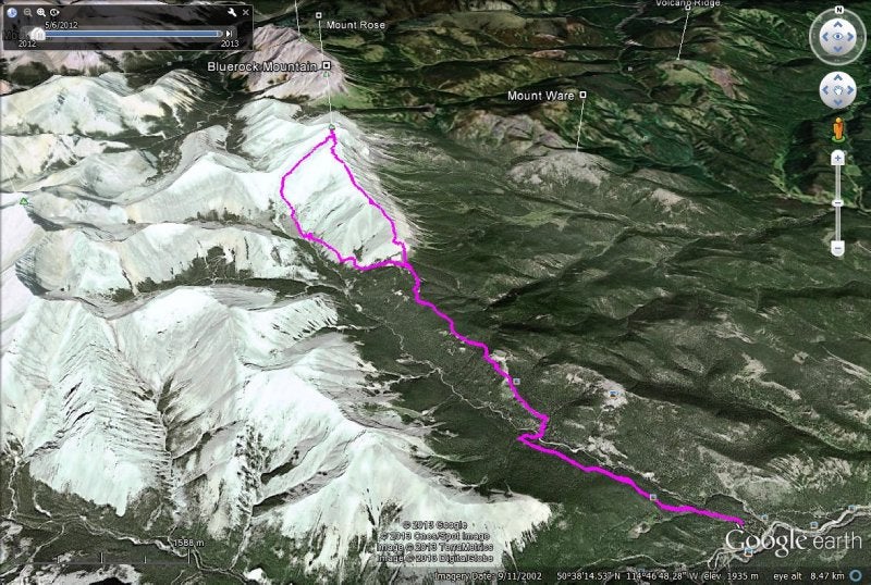
My GPS track: https://www.dropbox.com/sh/3kbo5a8hx...tain%20001.gpx


I don't have time these days to post long trip reports. Decided to make an exception for this one as I think Bluerock Mountain is undeservingly ignored. I was surprised I could find only Bob and Sonny's TRs when doing research for this mountain. I'm a big fan of long ridgewalks that Bluerock Mountain is known for, so I was glad to join Jeff jeffs78 and others on a club trip organized by Jeff.

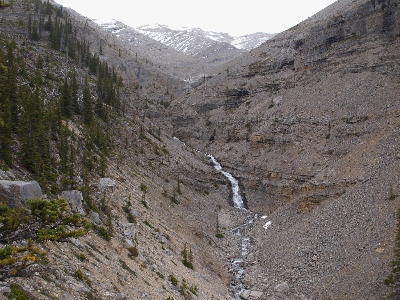
It turned out a very pleasant outing. We followed South Ridge as described in G. Daffern's latest edition of "Kananaskis Trail Guide". Jeff brought the description. I had Bob Spirko's GPS track but it was not needed as routefinding was pretty easy. A broad equestrian trail (Bluerock Creek Trail) brought us quickly to the base of the mountain and above the treeline, thus eliminating any bushwhacking. The only difficulty was crossing Bluerock Creek on what was once a bridge. Some opted to get their feet wet.

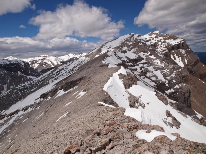
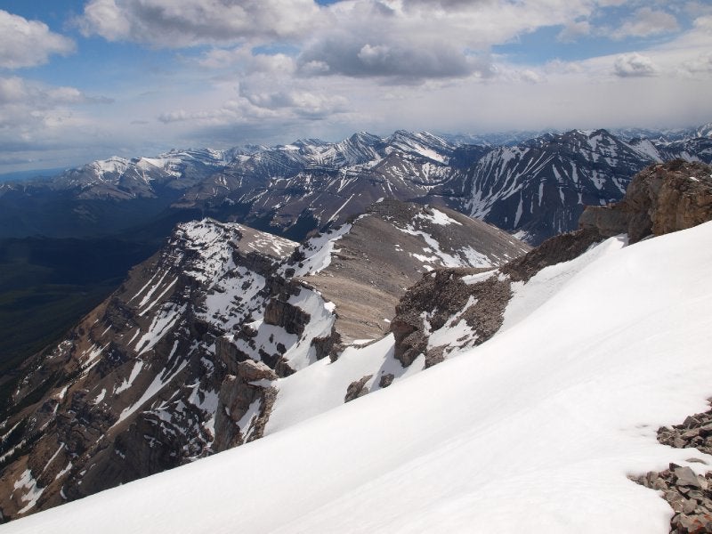
Once we gained the summit ridge (what G. Daffern calls 
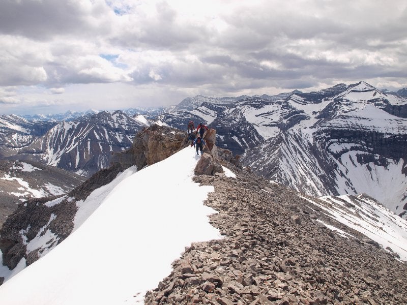
Kiska Mnoga Iyarhe Mountain) we were treated with a pleasant and long ridgewalk on undulating summit ridge over a series of false summits. The only challenging part was getting through the 2nd false summit / cliff band, or the first one after Kiska Mnoga Iyarhe. G. Daffern describes the route up and it's sort of obvious. There is only one gully on the left that offers a straightforward way through:


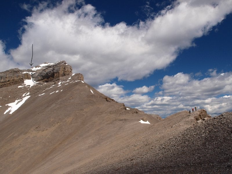
That gully was filled with snow. Nothing serious for competent scramblers but at least 2 less experienced members of our party had some problems ascending it. One of them slipped on wet rock and stepped on my finger.

Once above the narrow gully you can go either left or right. There is a large cairn on the left but that route looked pretty intense in the given condition. We had to cross a steep snow-covered slope right above a drop-off. When I was dealing with the pain shock and getting treatment to stop blood spilling from the crushed finger, Jeff and others found a much easier way up on the right. I obviously followed them once coming back to my senses.

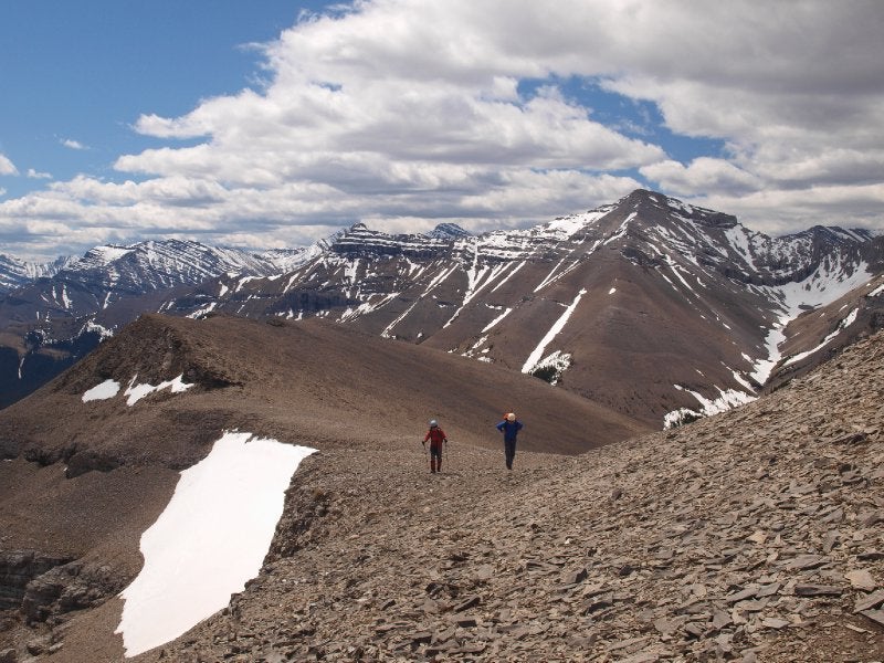
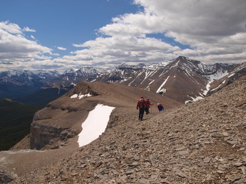
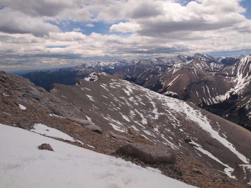
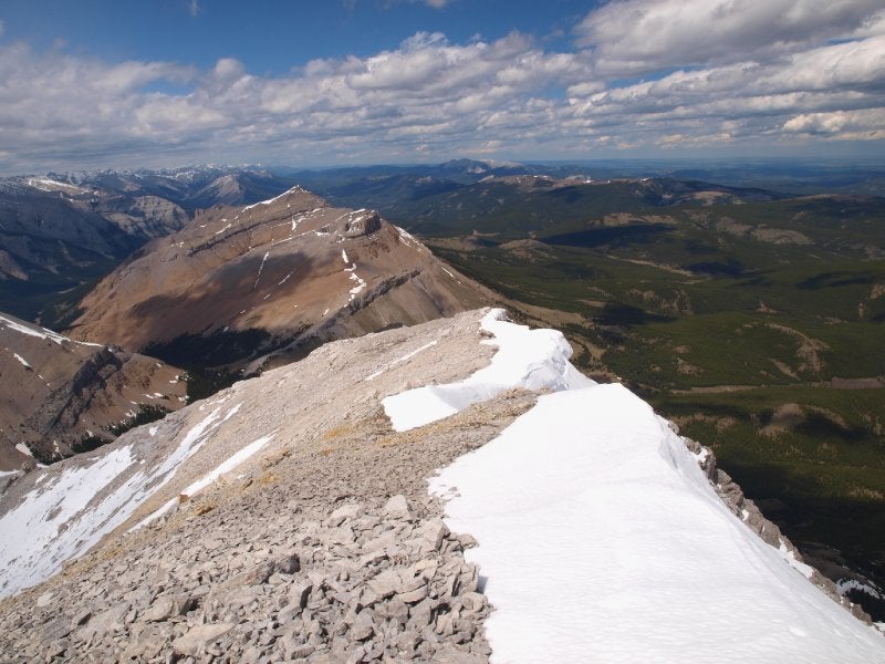
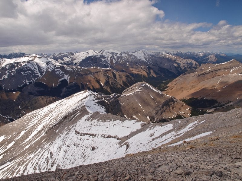
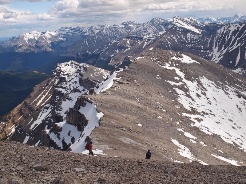
The rest was a very enjoyable ridgewalk over a series of bumps. You can follow the ridgeline (moderate exposure) or avoid it altogether by dropping a bit left. Routefinding is fairly simple. If any difficulties encountered - look for an easier way on the left. The last bit to the summit after the 4th false summit is just a pleasant hike/easy scramble. The summit offers nice views over the foothills towards Mt. Ware, Forgetmenot Ridge and Moose Mnt. Rose and Threepoint Mnts are prominent in the north, while Burns, Cougar, and Banded-Glasgow group dominate in the west.

On the way back we dropped to Upper Bluerock Creek, then rejoined the equestrian trail (Bluerock Creek Trail) at the base of the mountain ("the bench"). This involved some tedious side-sloping that slowed us down a bit. It was a very good decision in the given conditions, as we saw menacing clouds approaching from the west and I heard the sound of thunder. We were also not certain that the less experienced members of the group would manage to descent that gully where I sacrificed my blood to nature. For competent scramblers, and when the weather is nice, I recommend retracing steps to enjoy the glorious ridgewalk for the second time, instead of scree bashing.

We completed the trip in over 12 hours, but this included at least 2 hours waiting for slower members of the group. Anyone traveling at the moderate pace can do it easily in 10 hours, especially if coming back the same way.

Highly recommended outing for those who enjoy long ridgewalks, especially as an early/late season destination.

Engor is offline  
Quote
Sponsored Links
Advertisement
 
post #2 of (permalink) Old 06-11-2013, 05:52 PM
High on the Mountain Top
 
Join Date: Apr 2006
Location: Okotoks, Alberta, Canada.
Posts: 1,884
Default

Excellent! Bluerock has been the backdrop to so many of my trips into the country around it's eastern flanks - Mt. Ware, Volcano ridge etc - usually in the shoulder seasons. I guess you could say it's on my 'list' as it is one of my favorite mountains. Good beta, thanks!
Sodbuster is offline  
post #3 of (permalink) Old 06-11-2013, 06:14 PM
High on the Mountain Top
 
Join Date: Jul 2009
Location: Calgary, Alberta, Canada.
Posts: 1,595
Default

Looks like a fun outing. I imagine the creek crossing would be easier in the fall.
Marko is offline  
Sponsored Links
Advertisement
 
post #4 of (permalink) Old 06-11-2013, 06:34 PM Thread Starter
High on the Mountain Top
 
Join Date: Jan 2007
Location: Calgary, , .
Posts: 1,010
Default

Thanks Clayton. Bluerock Mountain is such dominant feature in Sheep Country, easily identifiable on Calgary skyline, offers a nice ridgewalk, and boasts a good access trail without bushwhack that I'm surprised it's not a popular outing.

Marko, the creek crossing is not a big problem even in this time of year. I was just too lazy to get my feet wet. [:I] Decided to use what is left of the bridge to cross the creek.
Engor is offline  
post #5 of (permalink) Old 06-12-2013, 03:26 PM
Headed for the Mountains
 
Join Date: Aug 2010
Location: , , .
Posts: 212
Default

There`s another route up Bluerock Mountain that I highly recommend. You start from the Ware Creek parking lot and you bike all the way to the Bluerock campground (I hope I got all the names right; don`t have the book with me). Don`t take the trail that goes to Mt. Ware. There are too many ups and downs. Instead bike north and then west towards the campground. The ride back down is awesome! From the campground take a trail that will land you between Mt. Rose and Bluerock Mtn. It`s a very nice spot. I`m gonna camp there one day. From there hike to the base of the north face of Bluerock Mountain and kick steps or slog up (if there`s no snow) directly to the summit. It`s a fun and the most direct route to the top of this beautiful mountain. You get to ride your mountain bike and climb a great mountain. It doesn`t get any better than this! I posted a few photos from this trip here: https://picasaweb.google.com/RPaul444/BLUEROCKMTN2789M# My round trip was 9 hours including 1 hour for breaks and a summit nap.
MtnNinja is offline  
post #6 of (permalink) Old 06-12-2013, 04:11 PM
High on the Mountain Top
 
dougz's Avatar
 
Join Date: Mar 2010
Location: Mackenzie, BC, Canada.
Interest: hiking, skiing, camping, SAR, Canadian Rangers (army reserve)
Posts: 1,515
Default

Wow.. I dunno if I'd have the stones to scramble up those vertical sections to get to those ridgelines.. Well done, and thanks for taking the time on the TR!
dougz is offline  
post #7 of (permalink) Old 06-12-2013, 05:01 PM Thread Starter
High on the Mountain Top
 
Join Date: Jan 2007
Location: Calgary, , .
Posts: 1,010
Default

Raff, I'm looking at GemTrek map of the area. Looks like you took Gorge Creek Trail to near Threepoint Mountain CG. There is no trail shown on the map that can take you from there to the pass between Bluerock Mnt and Mt. Rose. I guess you followed game paths or abandoned trails. If I remember correctly G. Daffern describes North Ridge route in her earlier editions of "Kananaskis Trail Guide", which is similar to the one you took.

You can approach South Ridge on bike too. Bluerock Creek Trail is easy to cycle on as far as the Creek crossing despite occasional windblown trees, which means effectively shaving off 3-3.5km each way. The trail goes too steep and has too much deadfall after that to offer an enjoyable ride to all but the most hardcore cyclists.

Thanks, Doug!
Engor is offline  
post #8 of (permalink) Old 06-12-2013, 05:39 PM
Super Moderator
 
KARVITK's Avatar
 
Join Date: Apr 2005
Location: Abbotsford, B.C., Canada.
Interest: Hiking, Snowshoeing, and Photography. Enjoying the outdoors fresh air and fitness experience.
Posts: 17,917
Default

That sure is beautiful country, what a privilege to live there and enjoy those peaks and valleys.

K
KARVITK is offline  
post #9 of (permalink) Old 06-12-2013, 05:41 PM
High on the Mountain Top
 
Join Date: Apr 2006
Location: Okotoks, Alberta, Canada.
Posts: 1,884
Default

Making a weekend of if with an approach from the north from a random camp was how I sorta had it figured but the ridge traverse is very appealing too. I sometimes bike approach, about once or twice a year, but I can't say I get too excited about it.
Sodbuster is offline  
post #10 of (permalink) Old 06-13-2013, 12:14 PM
High on the Mountain Top
 
vern.dewit's Avatar
 
Join Date: Mar 2008
Location: Calgary, Alberta, Canada.
Posts: 1,155
Default

Quote:
quote:Originally posted by Engor

Raff, I'm looking at GemTrek map of the area. Looks like you took Gorge Creek Trail to near Threepoint Mountain CG. There is no trail shown on the map that can take you from there to the pass between Bluerock Mnt and Mt. Rose. I guess you followed game paths or abandoned trails. If I remember correctly G. Daffern describes North Ridge route in her earlier editions of "Kananaskis Trail Guide", which is similar to the one you took.

You can approach South Ridge on bike too. Bluerock Creek Trail is easy to cycle on as far as the Creek crossing despite occasional windblown trees, which means effectively shaving off 3-3.5km each way. The trail goes too steep and has too much deadfall after that to offer an enjoyable ride to all but the most hardcore cyclists.

Thanks, Doug!
Two options now... Funny, we were totally thinking of doing this one last weekend and changed to Erickson due to a nicer weather forecast in Crowsnest.
vern.dewit is offline  
post #11 of (permalink) Old 06-13-2013, 03:01 PM
Headed for the Mountains
 
Join Date: Aug 2010
Location: , , .
Posts: 212
Default

This approach is terrific for people who love mountain biking. I did the Gorge Creek loop a few years ago and loved it. It is one of the best biking routes in the Rockies. You start at the Gorge Creek trailhead, 4 km fro mthe SR 546. It`s not the Ware Creek trailhead as I stated in my previous post). Gorge Creek is well named. There`s a well defined trail that takes you to the pass between Bluerock and Rose. It starts at the junction of Gorge Creek trail and the Threepoint trail. Originally I intended to do the north ridge as described by Daffern, but I ended up going straight up the face. The north ridge route starts right at the pass. You go up a scree slope and then you follow the ridge to the summit. The north ridge is a safer route, especially when the north face is covered in snow. Bluerock Mountain is a lot of fun and one of the most prominent mountains you can see from Calgary.
MtnNinja is offline  
post #12 of (permalink) Old 06-13-2013, 06:19 PM Thread Starter
High on the Mountain Top
 
Join Date: Jan 2007
Location: Calgary, , .
Posts: 1,010
Default

Vern, lol, that would have been funny to bump into each other. In this case, I think, Bluerock Mnt. would have witnessed the record number of peak-baggers on a single day in its history!

Raff, thanks for the beta! Good to know about the other approach.
Engor is offline  
post #13 of (permalink) Old 06-13-2013, 09:12 PM
Headed for the Mountains
 
Join Date: Jan 2009
Location: , , .
Posts: 334
Default

For those wanting to give Bluerock Mountain a go. Please take up a new register as there was none up there. I only had one with me and used it for Allsmoke Mountain the previous day. Thanks!
jeffs78 is offline  
post #14 of (permalink) Old 06-13-2013, 09:21 PM
Summit Master
 
Join Date: Jul 2003
Location: PNW
Posts: 8,493
Default

Quote:
quote:Originally posted by MtnNinja

This approach is terrific for people who love mountain biking. I did the Gorge Creek loop a few years ago and loved it. It is one of the best biking routes in the Rockies. You start at the Gorge Creek trailhead, 4 km fro mthe SR 546. It`s not the Ware Creek trailhead as I stated in my previous post). Gorge Creek is well named. There`s a well defined trail that takes you to the pass between Bluerock and Rose. It starts at the junction of Gorge Creek trail and the Threepoint trail. Originally I intended to do the north ridge as described by Daffern, but I ended up going straight up the face. The north ridge route starts right at the pass. You go up a scree slope and then you follow the ridge to the summit. The north ridge is a safer route, especially when the north face is covered in snow. Bluerock Mountain is a lot of fun and one of the most prominent mountains you can see from Calgary.
good to see you still post, will definately have to hit you up for real time info, once we get our butts out your way
Aqua Terra is offline  
post #15 of (permalink) Old 06-14-2013, 06:48 PM
Summit Master
 
zeljkok's Avatar
 
Join Date: May 2009
Location: Anywhere except social media
Posts: 5,435
Default

That is a great TR and very nice photos, with bonus links to various other reports (of well known local celebrities . Interesting to note Nugara turned back on his mid-May attempt because of too much postholing.
zeljkok is online now  
Reply

Thread Tools
Show Printable Version Show Printable Version
Email this Page Email this Page


Posting Rules  
You may not post new threads
You may not post replies
You may not post attachments
You may not edit your posts

BB code is On
Smilies are On
[IMG] code is On
HTML code is Off
Trackbacks are On
Pingbacks are On
Refbacks are On

 
For the best viewing experience please update your browser to Google Chrome
 

Search Engine Optimization by vBSEO 3.6.1