Sky Pilot Valley (Squamish Gondola) - ClubTread Community

User Tag List

 1Likes
Reply
 
LinkBack Thread Tools
post #1 of (permalink) Old 06-21-2014, 03:47 PM Thread Starter
Summit Master
 
zeljkok's Avatar
 
Join Date: May 2009
Location: Anywhere except social media
Posts: 5,435
Default Sky Pilot Valley (Squamish Gondola)

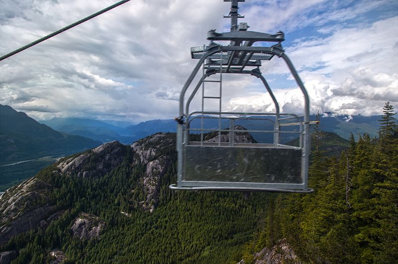
One of 6 Hiking trails advertised on Squamish Gondola web site. Seasoned back-country users will likely smirk at this one, as it is really just (a portion of) approach one used to make when ascending Sky Pilot. Having been steadily gaining weight from sitting on couch watching World Cup in Brazil and eating junk food, I finally decided I can afford to skip Honduras-Ecuador game and make use of my season pass for a little leg stretcher. Before I give description of the "trail", few pics from inside the gondola cabin -- which this time I had to myself both ways:


Walls on this one seem to have fallen off. Perhaps safety discussion raging in other thread is in place after all


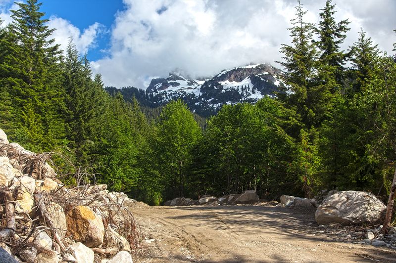
Now for the trail: Past upper gondola terminal descend to Shannon FSR (now called "Back-country Access Road) and go up. Past Klettergarten climbing rock, Al's Habrich Ridge spur and Sea-to-Summit junction is long stretch of mainly flat and wide road. I could see why Sky Pilot hikers of old would bring mountain bikes. This part is quite boring, and just as I started thinking entire day might be spent like this I got to this little quarry and end of cleared and widened section:


Old overgrown FSR is beyond this point, and within 5 minutes you arrive to important junction: Sky Pilot trail branches left, while Skyline/Shannon Loop access descends to the right. Arrow made of rocks, another remnant of old days, points to the left. Nearby is also blue "Sky Pilot Valley" marker #1:


This junction is some 20-30 minutes of moderate pace from upper gondola terminal. At this point Shannon creek is fairly close; its roar is constant companion for the remainder of the journey. There has been almost no elevation gain to this point, but now trail starts gentle but steady ascent to upper valley. Occasional orange flag but no markers for quite awhile; they resume from #13 (?! - on descent I paid attention but could not spot any between 1-13. Not that they are needed either). This part is also quite dark; I understand it used to be unpleasant alder bash, but now it has been brushed off and going is fairly easy. Occasional clearings in canopy above grant views of Mt. Habrich shapely summit cone:


20-25 minutes of such going brings you to next important junction: Flagged climber access trail to Mt. Habrich branches to the left. At this point alder tunnel has opened up and there are also semi-obscured views to upper valley. Word on this trail: I heard many accounts of its steepness (Gondola site recommends 'not to go that way, unless you are a climber'!) On return I hiked a bit up; it is very rough, but fairly well defined and flagged so it is probably reasonable although I'd much rather ascend this way than descend):


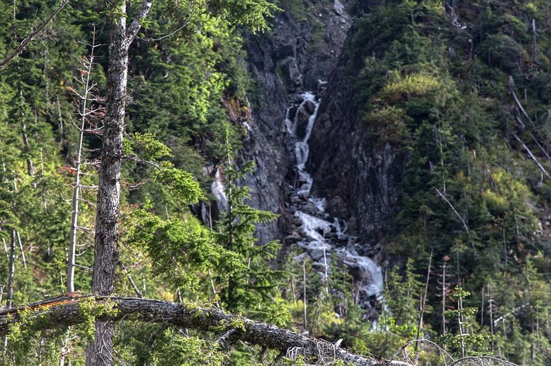
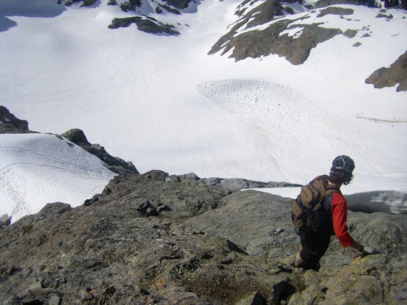
Sky Pilot trail continues straight. Next bit is very rocky and unpleasant: Up a creek-bed that had water flowing. That done with, tunnel opens up for good and final bit is quite enjoyable with views across the valley and cascading waterfalls descending from Stadium Glacier above. Finally, just as you near the headwall of upper valley is end of marked trail; rough route providing access to Sky Pilot continues. Out of curiosity -- as Sky Pilot is now in the cards for me, due to agreeable approach conditions -- I followed it for a bit: Going gets at least twice more difficult and slower immediately. It is fairly well defined and flagged though -- up across small boulder field where cairns mark the way, then next to a creek. First snow patches start here; it was almost 8pm, so I turned around, not wanting to risk losing last gondola. Few pics:


Return to Gondola terminal took just above an hour. To conclude: Real value of this trail is really as access point to either Sky Pilot alpine, or Mt. Habrich. It could still be an agreeable half-day walk when ambitions are not too high, or out of curiosity to take a closer peek at upper Shannon Creek valley. Standard map:
About 10km return and 450m elevation gain

(And if you ask me who is going to win the World Cup, it's Argentina all the way. No, I'm not Argentinian; I don't even particularly like Leo Mesi. But there are many reasons why this is their time)
zeljkok is online now  
Quote
Sponsored Links
Advertisement
 
post #2 of (permalink) Old 06-22-2014, 12:43 AM
Super Moderator
 
KARVITK's Avatar
 
Join Date: Apr 2005
Location: Abbotsford, B.C., Canada.
Interest: Hiking, Snowshoeing, and Photography. Enjoying the outdoors fresh air and fitness experience.
Posts: 17,917
Default

Sweet , great TR. Look forward to doing this trail as well.

K
KARVITK is offline  
post #3 of (permalink) Old 06-23-2014, 12:03 AM
Hittin' the Trails
 
Join Date: Jul 2010
Location: Whistler, , .
Posts: 16
Default

Thanks for the info, we summited Sky Pilot today. Great scramble.
Took us 6 1/2 hours round trip from the top of the gondola: 3 1/4 hour ascent, 1/2 hour summit break, 2 3/4 hour return. Good glissading on the way back, the snow is a knee saver this time of year. Total elevation gain for the trip 1250m.
Quite a bit of traffic now with the easy access, probably saw over a dozen people in the alpine, 2 other couples on the peak.
The Sky Pilot beer was appropriate afterwards.
Get it while it's good!
mark-r is offline  
Sponsored Links
Advertisement
 
post #4 of (permalink) Old 06-23-2014, 01:01 AM
High on the Mountain Top
 
Join Date: Sep 2004
Location: Vancouver, BC, Canada.
Interest: Mountains,skiing,cooking,Conspiracies,reading
Posts: 1,280
Default

Good to see the Sky Pilot area becoming more accessible[but not too accessible]Back in the mid 80s the road was pretty good,we used to drive up to where you went today.Should be lots of trs from the area coming up.That gondola is a great idea.
tedoliver is offline  
post #5 of (permalink) Old 06-23-2014, 12:34 PM
High on the Mountain Top
 
Join Date: May 2004
Location: Burnaby, BC, Canada.
Posts: 1,290
Default

Thanks for the report, Zeljkok! We were just discussing how the gondola will really improve access to the area. On that note, I'd love to see your trip photos, Mark-r!

Ted, the first time I climbed Sky Pilot, we too drove to the end of that road - point 4 in Zeljkok's map. When I tell people that, I get the impression they don't really believe that this was possible only 20 years ago. It sounds like a big fish story.

PB
Peak Bagger is offline  
post #6 of (permalink) Old 06-23-2014, 01:46 PM
High on the Mountain Top
 
Join Date: Sep 2004
Location: Vancouver, BC, Canada.
Interest: Mountains,skiing,cooking,Conspiracies,reading
Posts: 1,280
Default

Yeah ,Rhys,we used to refer to point 4 as the"Sky Pilot Parking Lot."You could be on the Stadium Glacier in about 30 minutes,if I recall correctly.You could also park directly under Habrich,and easily get to the standard route.
tedoliver is offline  
post #7 of (permalink) Old 06-23-2014, 03:09 PM Thread Starter
Summit Master
 
zeljkok's Avatar
 
Join Date: May 2009
Location: Anywhere except social media
Posts: 5,435
Default

Quote:
quote:
Good to see the Sky Pilot area becoming more accessible[but not too accessible]That gondola is a great idea.
Exactly reflects my sentiment. Casual Grind/Chief/etc. hordes will still be kept at bay, but folks that love to venture into back-country now don't need 4WD, or spend half day+loads of energy slogging up Indian/Shannon FSR from near sea level. Don't want to venture into another Gondola discussion, but first impressions usually count most and mine was "This is a great thing".

Quote:
quote:
the first time I climbed Sky Pilot, we too drove to the end of that road - point 4 in Zeljkok's map. When I tell people that, I get the impression they don't really believe that this was possible only 20 years ago. It sounds like a big fish story.
From how it looks today it is easy to see why some would think it was fish story But it is great testament how nature reclaims "its own" with time, isn't it.

Quote:
quote:
we summited Sky Pilot today. Great scramble.
Took us 6 1/2 hours round trip from the top of the gondola: 3 1/4 hour ascent, 1/2 hour summit break, 2 3/4 hour return. Good glissading on the way back, the snow is a knee saver this time of year. Total elevation gain for the trip 1250m.
Congratulations! I'd love to see some photos as well.
Question, so I can sink my own pace to your time: How long it took you from top of the gondola to end of marked trail?
zeljkok is online now  
post #8 of (permalink) Old 06-23-2014, 04:27 PM
Hittin' the Trails
 
Join Date: Jul 2010
Location: Whistler, , .
Posts: 16
Default

Quote:
quote:
Congratulations! I'd love to see some photos as well.
Question, so I can sink my own pace to your time: How long it took you from top of the gondola to end of marked trail?
I didn't check time precisely but I figure a little over an hour to the end of the marked trail where you start climbing the headwall towards the alpine.
I'm rounding up the photos and will post some soon.
mark-r is offline  
post #9 of (permalink) Old 07-02-2014, 03:00 AM
Hittin' the Trails
 
Join Date: Jul 2010
Location: Whistler, , .
Posts: 16
Default

Here are a few shots as promised. Great terrain!
Lenagen likes this.
mark-r is offline  
post #10 of (permalink) Old 07-02-2014, 08:34 AM
High on the Mountain Top
 
xj6response's Avatar
 
Join Date: Jul 2010
Location: Sunshine Coast, BC, Canada.
Posts: 2,319
Default

Quote:
quote:Originally posted by mark-r

Quote:
quote:
Congratulations! I'd love to see some photos as well.
Question, so I can sink my own pace to your time: How long it took you from top of the gondola to end of marked trail?
I didn't check time precisely but I figure a little over an hour to the end of the marked trail where you start climbing the headwall towards the alpine.
I'm rounding up the photos and will post some soon.
mark-r

did you happen to plot your path up to the top and maybe have a GPX of the route you'd be willing to share? Having never ascended sky pilot before, would be much obliged.
xj6response is online now  
post #11 of (permalink) Old 07-02-2014, 12:50 PM
High on the Mountain Top
 
Join Date: Apr 2006
Location: Rome Italy
Interest: Climbing
Posts: 1,219
Default

I was told it was a 20 min walk from the gate on the road to the gondola top.
J Mace is offline  
post #12 of (permalink) Old 07-02-2014, 03:04 PM Thread Starter
Summit Master
 
zeljkok's Avatar
 
Join Date: May 2009
Location: Anywhere except social media
Posts: 5,435
Default

Quote:
quote:Originally posted by mark-r

Here are a few shots as promised. Great terrain!
Sweet, thank you! Is lower crux (pink slab) left or center buttress on this photo?


zeljkok is online now  
post #13 of (permalink) Old 07-02-2014, 04:10 PM
Off the Beaten Path
 
Join Date: Sep 2008
Location: north shore, BC, Canada.
Interest: Uh... hiking? :P I love love love the outdoors. And I like shiny things. Been hiking, mostly solo, for over 20 years. You might assume that makes me antisocial. And you would be right *g* Climbed rock and ice and mountains for many years too...
Posts: 841
Default

It might be an Argentina v Brazil final. I would prefer Netherlands v Germany but it sort of feels like an Americas World Cup. Nice TR, too
icevixen is offline  
post #14 of (permalink) Old 07-02-2014, 05:36 PM
High on the Mountain Top
 
Join Date: Apr 2006
Location: Rome Italy
Interest: Climbing
Posts: 1,219
Default

Quote:
quote:Is lower crux (pink slab) left or center buttress on this photo?
Now that people are walking their dogs to the summit...

http://altusmountainguides.com/wp-co...-Sky-Pilot.jpg
J Mace is offline  
post #15 of (permalink) Old 07-03-2014, 12:26 AM Thread Starter
Summit Master
 
zeljkok's Avatar
 
Join Date: May 2009
Location: Anywhere except social media
Posts: 5,435
Default

Quote:
quote:Originally posted by icevixen

It might be an Argentina v Brazil final. I would prefer Netherlands v Germany but it sort of feels like an Americas World Cup. Nice TR, too
Didn't think anyone would pick up on World Cup rant [8D]

Yes, scripts are written for Brazil-Argentina final. But I'm not so sure anymore. Brazil has worst team I can remember, and Argentina is not much better - but has benefit of wild card Mesi. Columbia and Netherlands have been 2 best teams so far, along with Belgium perhaps. So just for laughs, although majority won't care, here is my 4-finals Crystal Ball:

Germany - France 3:2 (Germany)
Brazil - Columbia 1:2 (Columbia)
Argentina - Belgium 1:1 (Argentina) (penalty shots)
Netherlands - Costarica 3:0 (Netherlands)

If correct, this would set up Netherlands - Argentina classic semi that would prove to be game of tournament.
zeljkok is online now  
Reply

Thread Tools
Show Printable Version Show Printable Version
Email this Page Email this Page


Posting Rules  
You may not post new threads
You may not post replies
You may not post attachments
You may not edit your posts

BB code is On
Smilies are On
[IMG] code is On
HTML code is Off
Trackbacks are On
Pingbacks are On
Refbacks are On

 
For the best viewing experience please update your browser to Google Chrome
 

Search Engine Optimization by vBSEO 3.6.1