Exodus - ClubTread Community

User Tag List

 
LinkBack Thread Tools
post #1 of (permalink) Old 04-14-2014, 07:28 AM Thread Starter
High on the Mountain Top
 
Stoked's Avatar
 
Join Date: Jan 2007
Location: , , .
Posts: 1,297
Default Exodus

Trip with Max and Dean. Drove Elaho Main to end of plowing about 3.5 km before branch E-600. Longish ascent to Exodus summit on the Pemberton Icecap. Max can add the statistics from his BaseMap but the vertical was about 2200 meters and the distance I would guess over 20 km. We did 7.5 km just on E-Main itself.


E600


E600


DeanP


Max


Sims Valley, Mount John Clarke on left.


Mount John Clarke. Unfortunately, the views started to haze out.


Outrigger Peak.


Deserted Peak and Deserted N1.


The so-called Abandoned Peak with Ponor Peak rising behind it.


Descent from Exodus.


Descent from Exodus.
Stoked is offline  
Quote
Sponsored Links
Advertisement
 
post #2 of (permalink) Old 04-14-2014, 12:35 PM
Headed for the Mountains
 
Join Date: Mar 2004
Location: vancouver, bc, Canada.
Posts: 227
Default

Looks like an awesome trip! On my to do list for sure.

How deep is the snow on the roads past where it's plowed?
trail_blazer3 is offline  
post #3 of (permalink) Old 04-14-2014, 03:13 PM
High on the Mountain Top
 
Join Date: May 2005
Location: Whistler, BC, Canada.
Interest: Exploring the Coast Mountains and surrounding ocean waters in all seasons.
Posts: 1,573
Default

That's a strong effort. 7.5 km on a logging road covered by snow is mind-sapping for normal humans...
msulkers is offline  
Sponsored Links
Advertisement
 
post #4 of (permalink) Old 04-14-2014, 04:04 PM Thread Starter
High on the Mountain Top
 
Stoked's Avatar
 
Join Date: Jan 2007
Location: , , .
Posts: 1,297
Default

Quote:
quote:Originally posted by msulkers

That's a strong effort. 7.5 km on a logging road covered by snow is mind-sapping for normal humans...
Mitch, yeah, we were disappointed, for sure, when the plough turned back. It's not what you want at the start of the day or the end.

TrailBlazer, snow was deep enough to high-center a standard clearance SUV or truck. But it was just one long patch in the shade for about 300 meters. Then we could have driven to E600 on ice although there were a couple more deepish patches of snow. Maybe you could lasso one of the numerous big ungulates in the area and persuade him to tow you. If you wait a couple of weeks the E-Main might clear and you can drive up E600 a bit.
Stoked is offline  
post #5 of (permalink) Old 04-14-2014, 05:02 PM
Headed for the Mountains
 
Join Date: Oct 2008
Location: , , .
Posts: 127
Default

34km distance, 2225 meters elevation gain
Maxim is offline  
post #6 of (permalink) Old 04-14-2014, 08:12 PM
High on the Mountain Top
 
Join Date: May 2005
Location: Whistler, BC, Canada.
Interest: Exploring the Coast Mountains and surrounding ocean waters in all seasons.
Posts: 1,573
Default

Quote:
quote:34km distance, 2225 meters elevation gain
msulkers is offline  
post #7 of (permalink) Old 04-15-2014, 07:57 PM
Headed for the Mountains
 
Join Date: Aug 2010
Location: , , .
Posts: 121
Default


http://deanperezbc.blogspot.ca/2014/...anch-e600.html

Longest ski descent I've done this year.

"I was pretty excited when Paul sent out an invitation to ski Abandoned/Deserted Peak, a mountains I've never heard before and Exodus as a back up plan. However, I was already committed to Mamquam trip with Craig. The conversation through e-mails among the group is pretty funny. Apparently, Paul is well known for bush skiing, so the first question always comes up with how much alders involved in the trip. In my case, who new to this kind of mode of traveling, it's always like a survival skiing to get down the mountain. I can't really complain because i'm definitely learning through this experience( the hard way!). As a matter of fact, I totally enjoy this kind of trip. The more difficult to access an area, the more I see awesome stuff. "

DeanP is offline  
post #8 of (permalink) Old 04-17-2014, 07:02 AM Thread Starter
High on the Mountain Top
 
Stoked's Avatar
 
Join Date: Jan 2007
Location: , , .
Posts: 1,297
Default

Dean it was a pleasure doing a trip with you and Max again. After you master jump turns your skiing will be awesome! Thanks for the trail breaking especially on the last 2 km across the summit plateau.

We were lucky the road was ploughed as far as it was otherwise the second backup plan was Limelight Creek. We could have faced hundreds and hundreds of meters of slide alder. But sometimes a little bush must be overcome for the mountains less frequently traveled.
Stoked is offline  
post #9 of (permalink) Old 04-17-2014, 02:00 PM
Hittin' the Trails
 
Join Date: May 2011
Location: , , .
Posts: 37
Default

Nice trip!

I got the inspiration for an Exodus trip via E600 after gazing across the valley a couple of years ago from Outrigger on a BCMC ski trip that you (Stoked) were leading.

Ended up going up there last May - we drove to just over 1000m on E600. Walked past the large snow patch that stopped our truck to the end of the road and then up though open forest to about 1400m, where we put skis on. 7.5 hours return vehicle to Exodus to vehicle. E600 was in great condition.


rodin is offline  
post #10 of (permalink) Old 04-17-2014, 03:17 PM Thread Starter
High on the Mountain Top
 
Stoked's Avatar
 
Join Date: Jan 2007
Location: , , .
Posts: 1,297
Default

Good to hear from you rodin. I think I saw a short report of your trip. Saw one by simonc, coastalclimber and sabine but can't recall if they were on skis. It's a great access route.

Yeah, I was kinda envious when everyone else drove high on that road and we slogged all the way from the bottom. The scales tipped the other way coming down. Those 18% grades made for a great ski down. It's the best logging road descent in my recent memory.
Stoked is offline  
post #11 of (permalink) Old 04-19-2014, 05:20 PM
Headed for the Mountains
 
Join Date: Mar 2004
Location: vancouver, bc, Canada.
Posts: 227
Default

Lots of great pictures!
Thanks for the info stoked, I'm thinking of heading up those roads soon to Mt John Clarke, or the Blanca/Exodus area. Hopefully I'll have something to post soon as well.

cheers, Mauro
trail_blazer3 is offline  
post #12 of (permalink) Old 04-25-2014, 05:46 AM Thread Starter
High on the Mountain Top
 
Stoked's Avatar
 
Join Date: Jan 2007
Location: , , .
Posts: 1,297
Default

Map of route:

http://www.mappingsupport.com/p/gmap...=50.267,-123.5

GPS coordinates by Max and thinned by Stoked to 100 meter density.

Note: last GPS point is at the microwave tower which is not right on the summit.

Stoked is offline  
post #13 of (permalink) Old 04-25-2014, 05:55 AM Thread Starter
High on the Mountain Top
 
Stoked's Avatar
 
Join Date: Jan 2007
Location: , , .
Posts: 1,297
Default

Quote:
quote:Originally posted by trail_blazer3

Lots of great pictures!
Thanks for the info stoked, I'm thinking of heading up those roads soon to Mt John Clarke, or the Blanca/Exodus area. Hopefully I'll have something to post soon as well.

cheers, Mauro
Mauro, if you go this weekend let me know what the road conditions are like. How far you drove etc.
Stoked is offline  
post #14 of (permalink) Old 05-12-2014, 10:08 AM
gum
Headed for the Mountains
 
Join Date: Sep 2004
Location: Vancouver, BC, Canada.
Posts: 265
Default

Four of us skied Exodus on Saturday, May 10. We were able to drive with an older version of a Nissan Pathfinder to just short of the 5km mark on E600 to 1050m where the road used to end. The road is very steep in two sections above switchbacks. I don't think my Subaru Forester AWD could have done it with a full load - first gear transmission is way too high. Ian used the low 4WD of his Pathfinder. We cleared a few larger rocks of off the road below the slide area about 1/2km up E600. The road has now been pushed further and into new clear cuts.

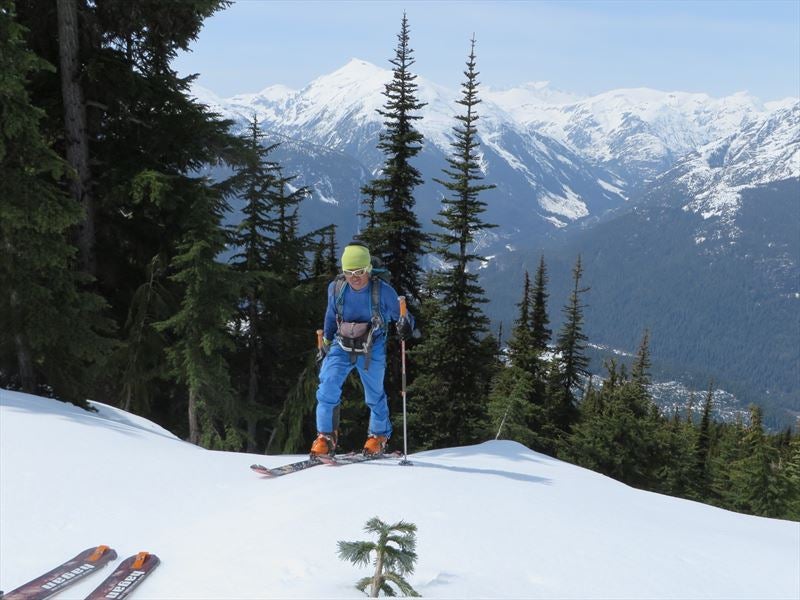
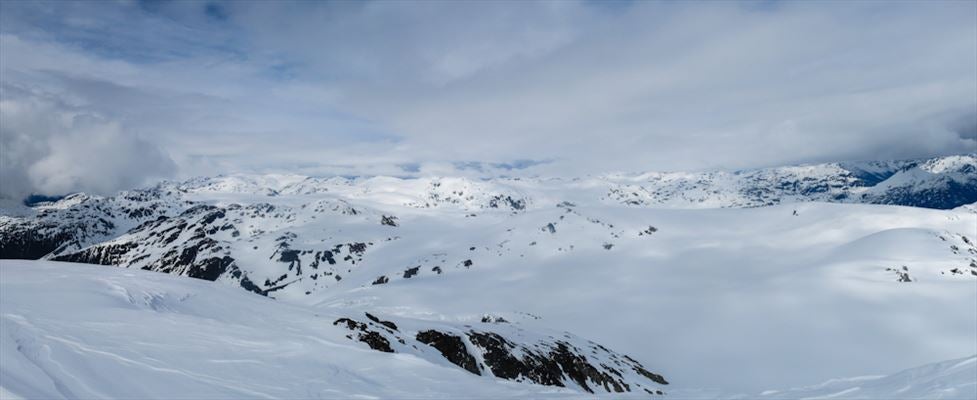
We found the forest to be rather convoluted with lots of short cliff bands. Eventually we meandered enough to the right to enter the low portion of an avalanche swath. This we ascended to below a prominent face with a broad ledge leading us to the far left to what looks like a ridge line. From there we found another convenient slope double back which put us into the alpine. We couldn't tell what was higher the bump with the microwave tower or the summit marked on the map.

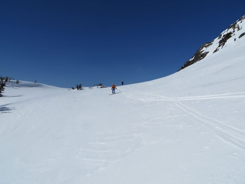
It was great spring skiing below the top with the occasional rock showing. From the ledge down, the snow was deep isothermal. There was fresh wet snow, only a day or two old over top of the spring layer. We purposely pushed this new snow, a good size wet avalanche down the narrowest portion of the avi-swath. It was then okay skiing down this freshly cleared slide path. The skiing in the open trees below was pretty good - not too soft and not too hard. About 7.5h round trip. It is a long drive - about 100km from Squamish and 23.5km + 5km from the Elaho turn-off across the Squamish River.
gum is offline  
Reply

Thread Tools
Show Printable Version Show Printable Version
Email this Page Email this Page


Posting Rules  
You may not post new threads
You may not post replies
You may not post attachments
You may not edit your posts

BB code is On
Smilies are On
[IMG] code is On
HTML code is Off
Trackbacks are On
Pingbacks are On
Refbacks are On

 
For the best viewing experience please update your browser to Google Chrome
 

Search Engine Optimization by vBSEO 3.6.1