Connecting the Dots: Table Meadows - ClubTread Community

User Tag List

Reply
 
LinkBack Thread Tools
post #1 of (permalink) Old 08-06-2012, 08:54 PM Thread Starter
Summit Master
 
zeljkok's Avatar
 
Join Date: May 2009
Location: Anywhere except social media
Posts: 5,435
Default Connecting the Dots: Table Meadows

Someone asked on Friday:

- Want to go hiking, maybe climb a peak?
- It is way too hot. I just want to drive up to some lake and take photos.

As if.


I have special fondness for Garibaldi; in my mind it rivals some of most celebrated Rockies areas, such as Lake O'Hara or Berg Lake. Looking at recent CT report ("A walk around Garibaldi Lake") and trip idea formed by itself. Let's just do an easy hike to the lake and take photos there. It will probably be cooler as well.

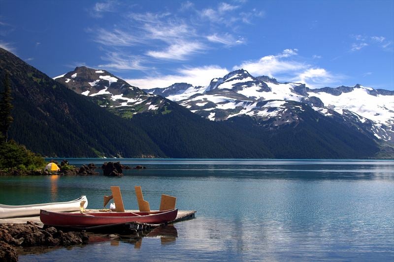
Trail was busy but I was prepared -- iPod with earbuds, and I zoned out. Took just over 2 hrs and I was crossing the outlet bridge. Camera came out instantly:


Lakeshore was busier than Robson Street on Friday night -- yells, screams, people swimming; all that made me continue a bit towards Ranger Station in search of some solitude. Just before the boat station, fence was erected warning to "stay away because of construction". Great. My gaze turned south towards Mt. Price. It is only few hours away, right? Two guys working at Ranger Station let me go, even if I was in "forbidden area". Boat and tent; what a way to live.


There was surprising lack of bugs (that was going to change in a hurry); I made a good progress, remembering which way to go on several potentially confusing sections from my previous trip couple of years ago. It was getting warmer so I made number frequent stops to capture constantly improving views behind me:


In 2 hour mark I was standing bellow scree slope leading up Clinker. This was luckily covered by snow allowing me for much easier ascent. Conditions:


Higher up I moved right to the ridge for couple more photos in westerly direction:


1. True Clinker with Tantalus in distance
2. Zoom on Tantalus
3. Sea of peaks west of Whistler
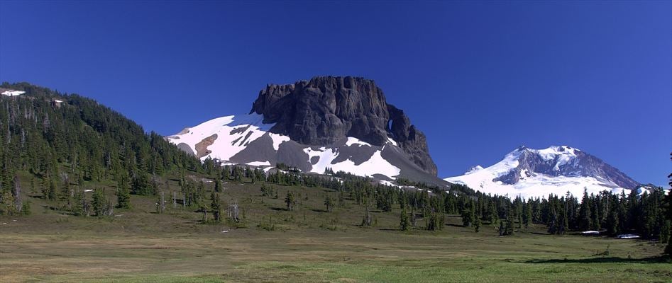
4. One more Tusk/Garibaldi shot

Mosquitoes started about here; there seemed to be magical boundary, about halfway up Clinker scree slope. From then on there was constant buzz around my ears with more than a dozen at any time on various parts of my body. I took Deet shower and continued. Descending a bit, soon I was approaching low saddle between Price and Clinker with fabulous views opening south:


1. Mt. Garibaldi through the gap on Price/Clinker col
2. Zoom on Glacier Pikes from the col
3. Panoramic view south: Table (L), Garibaldi (C). Sea of peaks above above Howe Sound in the distance (R)

Took few minutes on col; turned towards Price final scree slope, but something was bugging me. I climbed most of peaks on Lake perimeter accessible to hikers; I crossed frozen Lake in winter on snowshoes couple of times. Last big project was hike around the lake of which the only part I was not entirely sure about was crossing between Sentinel Bay and Mt. Price. I recalled Ryan's report last year -- he was able to visit meadows under the Table and hike back in a day, but I didn't remember the details. I considered some more. I decided to take a peek. From above route was not obvious -- after only few minutes I ended in thick bush. I backtracked, then traversed left (east) reaching big open gully that seemed open all the way down. So much for the easy day out taking photos. My eventual route:


Going down I made a mistake. I thought I'd take more direct route, so I constantly kept angling left aiming in general direction of Table. I crossed couple of gullies and 2 burn areas, which all went reasonably well. But I was still too high when I turned completely east -- this led to one uncomfortable bone-jarring descent down tree slope of drainage that eventually leads to Table Bay. Correct path -- taken on return -- is to descend gully bellow Price/Clinker all the way down, then go left. This route was taken on return and avoided most of the problems. Still, after about 1 1/2 hours I was entering Table Meadows:
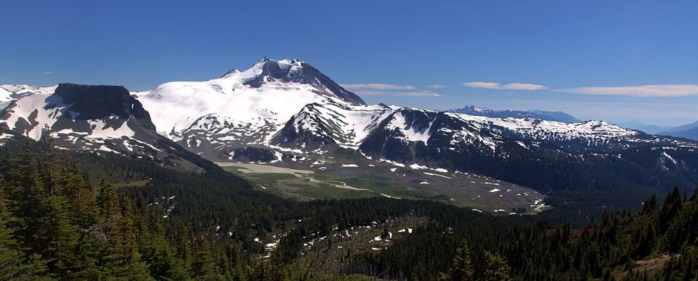

1-2: Table Meadows
3: Table Handle

What a fantastic place this was! Very pristine in fantastic surroundings. Quite a few -- mostly flowing -- small bodies of water, than would make it a perfect camping spot.


I replenished my water supplies (5 liter so far gone), then headed back -- even if I toyed for a second with an idea of simply staying overnight and sleeping on soft grass. On return I circled more south avoiding all nasty micro-terrain; it all well so surprisingly well. I thought about ascending gully directly bellow Mt. Price -- it was open, and there were someone tracks in the dirt higher up. Eventually I decided on best line of ascent -- followed the rib (old burn area) in the lower part, just left (west) of gully under Price/Clinker, then moved in halfway up and groveled my way to the col. Photos taken from burn area:


Emerging to Price/Clinker col in about 40 minutes I finally lost my steam. I started feeling lethargic -- I was probably dehydrated. Took another 20 to summit of Price; every step seemed like a monumental effort. Heat and effort took their toll. I crashed by summit cairn and slept for half an hour; waking up I felt somewhat refreshed and took some more photos:


Nice pano stitch made of 3 shots for entire length of the Lake:


It was almost 8 pm when I started my descent from Price. For some reason whenever I go to Garibaldi, I end up hiking out with headlamp. I guess pretty soon I'll be able to do it with a blindfold. I hurried wanting to get back to the lake before dark (couple of boulder sections in lower part of Price trail), but still had to use light for last 1/2 hour. Resting at the lake I watched phenomenal sight: What looked like a giant light beam illuminating glacier behind Castle Towers slowly grew brighter -- eventually moon came out. I wished I had my tripod (and more energy).

This was one of most satisfying exploratory trips I ever did, in such phenomenal surroundings. It was also very tiring: 40+ km with over 2500 cummulative vertical -- according to GPS. I am getting too old for this; someone call Steven Song.

I have now touched all Garibaldi Bases; all that remains is to connect the dots. Stay tuned...

High-res photos here: https://picasaweb.google.com/1167471...eat=directlink
zeljkok is online now  
Quote
Sponsored Links
Advertisement
 
post #2 of (permalink) Old 08-06-2012, 08:59 PM
Summit Master
 
Ryan.in.yaletown's Avatar
 
Join Date: May 2008
Location: Van, BC, Canada.
Posts: 3,230
Default

I agree, it's a very cool area that not too many people get to experience. Sounds like your ascent line was the exact one I took - too bad you didn't read my TR to get the details before descending!

-Ryan

Edit: one year plus one day after my trip. Interesting to see the lack of snow this year compared to last.
Ryan.in.yaletown is offline  
post #3 of (permalink) Old 08-06-2012, 09:04 PM
Off the Beaten Path
 
NS Explorer's Avatar
 
Join Date: May 2004
Location: North Vancouver, , Canada.
Interest: Hiking, Scrambling, Trail Running, Mountain Biking, SAR
Posts: 843
Default

Nice one. Great shots of the Table.
NS Explorer is offline  
Sponsored Links
Advertisement
 
post #4 of (permalink) Old 08-06-2012, 09:24 PM
High on the Mountain Top
 
Join Date: Jun 2010
Location: , BC, Canada.
Posts: 2,463
Default

When I looked at the image of the GPS tracks I assumed this was a multi-day trip. Great job getting it done in a day.

I love this picture:
Steventy is offline  
post #5 of (permalink) Old 08-06-2012, 09:26 PM
Headed for the Mountains
 
Join Date: May 2009
Location: West Vancouver, B.C., Canada.
Posts: 351
Default

Very enjoyable trip report and awesome photos.

Thank god there is more to life than painting and power washing.
craigS is offline  
post #6 of (permalink) Old 08-06-2012, 09:57 PM
Headed for the Mountains
 
Join Date: Sep 2011
Location: Vancouver, BC, Canada.
Posts: 229
Default

Might have been my tracks you saw - I was up on Price around noon on Saturday. Mosquitoes were savage on the ascent up Clinker and even followed me all the way to the summit of Price.
The guys who were "working" on the ranger station definitely had a nice setup - tents, beer, tanning on the dock. Didn't see too much actual construction going on but hey, it was the weekend.
mj24 is offline  
post #7 of (permalink) Old 08-07-2012, 06:59 AM
tu
High on the Mountain Top
 
tu's Avatar
 
Join Date: Apr 2010
Location: Burnaby, BC, Canada.
Posts: 1,753
Default

Thanks for the TR - really enjoy viewing all the terrific photos.

I understand what you mean about Garibaldi and headlamps. This place so encourages one to linger and savour, that we've never been able to leave till dark, either.
tu is offline  
post #8 of (permalink) Old 08-07-2012, 12:22 PM Thread Starter
Summit Master
 
zeljkok's Avatar
 
Join Date: May 2009
Location: Anywhere except social media
Posts: 5,435
Default

Thanks everyone for comments!

Ryan -- I read your TR; but if you remember to the left (north) of Meadows there is small mostly open rise (maybe 20 minutes more?). It is in far left of this photo:

That was my ultimate goal -- thought I'd get a view of the Lake and Sentinel Bay from there. It appears deceivingly close from Price/Clinker col in fact. Descending I took most direct path in that direction -- which led to some uncomfortable micro-terrain which caused me to lose too much time. I still think if one hikes to Meadows via "correct" path (roughly between 2 GPS lines in my TR), this is phenomenal day objective -- 1 1/2 hr from col at most.

Tu -- agreed. Next time I am heading up I am taking tripod with me. For few years I am toying with idea of bivying on top of Price; sunset/sunrise photos from there must be spectacular. Only problem -- there is no reliable water, but there is large snowpatch that is likely permanent.


zeljkok is online now  
post #9 of (permalink) Old 08-07-2012, 09:42 PM
Super Moderator
 
KARVITK's Avatar
 
Join Date: Apr 2005
Location: Abbotsford, B.C., Canada.
Interest: Hiking, Snowshoeing, and Photography. Enjoying the outdoors fresh air and fitness experience.
Posts: 17,917
Default

Quote:
quote:Originally posted by zeljkok

Thanks everyone for comments!

:


Awesome photo set, and this is my favourite. Truly a delightful day for taking so many beautiful photos of outstanding quality. You have inspired me to visit TAble Meadows...

Beautiful area.

K
KARVITK is offline  
post #10 of (permalink) Old 08-07-2012, 09:54 PM
Headed for the Mountains
 
Join Date: Sep 2009
Location: Poco, BC, Canada.
Posts: 452
Default

Thanks for this, this is an area I'm desperate to get to (table meadows). This just reaffirms my need to get there.
gdichasaz is offline  
post #11 of (permalink) Old 08-07-2012, 10:28 PM
Headed for the Mountains
 
Join Date: Nov 2008
Location: Burnaby, BC, Canada.
Posts: 259
Default

Quote:
quote:Originally posted by zeljkok

Nice pano stitch made of 3 shots for entire length of the Lake:
Spectacular panorama!!!

I've only been as far as the top of Clinker, thanks for the motivation to try going further next time...!
sansell is offline  
post #12 of (permalink) Old 08-08-2012, 10:43 AM Thread Starter
Summit Master
 
zeljkok's Avatar
 
Join Date: May 2009
Location: Anywhere except social media
Posts: 5,435
Default

Thanks Karl, Glen and Steve

Just want to say again -- in my opinion Table Meadows are not best done as day trip from Rubble Creek. Not only because distance & elevation, but also because once there you don't have any time to explore. I studied a bit topo maps --- partially treed rise to north would give very unique perspective of the Lake. Hike towards Sentinel Bay, or explore around the Table. Follow the drainage down to Table Bay perhaps? There are many possibilities. 3 Day / 2 night camp would be interesting alternative.

zeljkok is online now  
post #13 of (permalink) Old 08-08-2012, 08:13 PM
Summit Master
 
Join Date: Jul 2003
Posts: 4,662
Default

given that this winter will likely be el Nin~o, the prospect of spending a long non-rainy/snowy weekend at Table Meadows is most appealing.
seawallrunner is offline  
post #14 of (permalink) Old 08-08-2012, 09:20 PM
Headed for the Mountains
 
NorthVanHiker's Avatar
 
Join Date: Jun 2006
Location: Port Coquitlam, BC, Canada.
Interest: Most things outdoors. And of course soccer. GO Arsenal!
Posts: 177
Default

Outstanding trip and photos of an area of Garibaldi not too often explored!
Thanks for sharing
NorthVanHiker is offline  
post #15 of (permalink) Old 08-08-2012, 09:32 PM
High on the Mountain Top
 
Join Date: Aug 2002
Location: Whooville
Interest: Love the outdoors. Trying new things. And at night......BOGGLE!
Posts: 1,821
Default

Crazy beautiful...very nice.
calixtomoon is offline  
Reply

Thread Tools
Show Printable Version Show Printable Version
Email this Page Email this Page


Posting Rules  
You may not post new threads
You may not post replies
You may not post attachments
You may not edit your posts

BB code is On
Smilies are On
[IMG] code is On
HTML code is Off
Trackbacks are On
Pingbacks are On
Refbacks are On

 
For the best viewing experience please update your browser to Google Chrome
 

Search Engine Optimization by vBSEO 3.6.1