Martin Peak (West) - 2012-03-31 - ClubTread Community

User Tag List

 
LinkBack Thread Tools
post #1 of (permalink) Old 04-01-2012, 10:49 AM Thread Starter
Summit Master
 
Ryan.in.yaletown's Avatar
 
Join Date: May 2008
Location: Van, BC, Canada.
Posts: 3,230
Default Martin Peak (West) - 2012-03-31

Photoset:
http://www.flickr.com/photos/realawo...7629716692213/

A group of 11 set off up the Mamquam Main, swung up the mountain at Martin Creek and made for the saddle between Martin West and East. Nearing the saddle 7 turned around due to avy risk, 4 continued on and successfully summited.


Elevation Profile:


Google Earth birdseye:
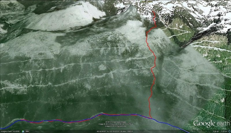

Google Earth 3d:


We set off up the Mamquam Main FSR. Consistent snowline (and our parking spot) was only at km14. The road has deteriorated since I was last up here last year. Potholes have increased in number and depth. Active logging along a few portions have made stretches more soft and loamy. A 2wd vehicle might be able to make it (Alastair's did last week), but it's not something I'd personally want to try.

Snowline was quite low, so we walked the 2.3 km along the road to Martin Creek. We didn't snowshoe and generally weren't punching through that badly since the snow on the road was pretty crusty and there were some old tyre/smowmobile tracks that had consolidated things a bit.

Still lots of melt needed on Mamquam FSR:


I understand the normal approach to the Martin West/East peaks is from the north, using the spur roads on the north. When asked about that, Alastair responded that such a route would be too easy

As you can see from the Google Earth images, this approach is basically one big cutblock series, crossing a number of old spur roads. Once in the forest, the crusty snow soon gave way to deeper and not so crusty; snowshoes went on pretty quickly.

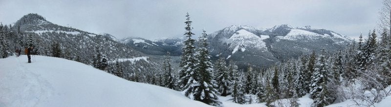
The higher we got, the deeper the snow got. The snow itself in the lower reaches was wet and heavy. Weather was warm enough (but not warm for spring!) with high level cloud. We had some views of the Mamquam River Valley from the occasional bluffy area:


The cutblocks made for very slow going. They must be older cuts, since there was some half decent regrowth. Still, with the openness came very deep wet snow. And postholing and treewells.


Our pace was about 1km/h at this stretch. With such a large group we tried to take turns breaking trail, the stronger ones spending more time up front.


It wasn't so much breaking trail rather than working to compress down the snow immediately in front of you so you could swim forwards. Higher up, it was mid-thigh for me. The wet heavy snow made this all the more difficult.

Jeff, either getting a bit peckish or trying to warm his fingers:


Crossing the 5th spur road seemed to be the magic level, since after that the wet snow disappeared and we were left with more powdery snow. The weather also closed in and it started snowing:


Avy forecast was moderate/moderate/considerable for below/at/above treeline. Nearing the saddle we reached a relatively open (a few trees, but what was there was surprisingly large for this elevation), steep (40-45-ish degrees) slope with a convex roll on the top and windblown snow. The top 4-6" were quite reactive (almost certainly a layer new storm snow or windslab). On top of all that, I heard a whoomp.

All of that made for an easy decision to pull the plug and head back. 6 others joined me. 4 of the group satisfied themselves of the safety and found safe routes past this area and made for the West summit (and successfully made it - they will have to fill in the details below).

After dropping down a little ways, the descending 7 decided to dig a quick pit and take a peek. My compression test revealed that the top layer of storm snow (only 2" or so at that location) was indeed weak (fractured on my 3rd wrist tap). Other than that, my column was solid.

Examining the snow profile, we found the icy crust from last weekend's sun/high temperatures buried roughly 1m (!) down. A Rutschblock Test suggested that the snow from the last week was internally pretty well bonded, but with decent effort would slide on that crust (yes I know, the column wasn't as long as it should have been):
http://www.flickr.com/photos/realawo...in/photostream


The descent through the wet deep treewelled snow was absolute hell on my knees, so I took it very slowly and carefully. Still, the descent was much quicker than the ascent and we were back on the road and then to the cars in no time. No summit, but still a great day to get out

-Ryan


Ryan.in.yaletown is offline  
Quote
Sponsored Links
Advertisement
 
post #2 of (permalink) Old 04-01-2012, 11:10 AM
High on the Mountain Top
 
Join Date: Jun 2010
Location: Squamish, British Columbia, Canada.
Posts: 1,360
Default

Quote:
quote:Originally posted by Ryan.in.yaletown
On top of all that, I heard a whoomp.
Did nobody else experience this?

leimrod is offline  
post #3 of (permalink) Old 04-01-2012, 12:48 PM
Super Moderator
 
KARVITK's Avatar
 
Join Date: Apr 2005
Location: Abbotsford, B.C., Canada.
Interest: Hiking, Snowshoeing, and Photography. Enjoying the outdoors fresh air and fitness experience.
Posts: 17,917
Default

Like that shot of the group single file.

K
KARVITK is offline  
Sponsored Links
Advertisement
 
post #4 of (permalink) Old 04-01-2012, 01:34 PM
High on the Mountain Top
 
Join Date: Sep 2004
Location: Vancouver, BC, Canada.
Interest: Mountains,skiing,cooking,Conspiracies,reading
Posts: 1,280
Default

Quote:
quote:Originally posted by leimrod

Quote:
quote:Originally posted by Ryan.in.yaletown
On top of all that, I heard a whoomp.
Did nobody else experience this?

Possibly the sound of Tom Fyles spinning in his grave.
tedoliver is offline  
post #5 of (permalink) Old 04-01-2012, 07:01 PM Thread Starter
Summit Master
 
Ryan.in.yaletown's Avatar
 
Join Date: May 2008
Location: Van, BC, Canada.
Posts: 3,230
Default

Quote:
quote:Originally posted by leimrod

Quote:
quote:Originally posted by Ryan.in.yaletown
On top of all that, I heard a whoomp.
Did nobody else experience this?

Some of the other members heard it (wasn't just in my head

-Ryan
Ryan.in.yaletown is offline  
post #6 of (permalink) Old 04-01-2012, 08:15 PM
Headed for the Mountains
 
Join Date: Apr 2008
Location: Vancouver, BC, Canada.
Posts: 205
Default

As always, a well written factual account.

Not to much to say about the summit, windy, cold, no visibility.
Alastair is offline  
post #7 of (permalink) Old 04-01-2012, 09:03 PM
Summit Master
 
Join Date: May 2002
Location: , , .
Posts: 2,833
Default

Good for y'all making your own decisions. It can be so tempting in a group to just follow the leader.

Again, impressed by what you do on snowshoes, but, don't you ever wonder how it would be on skis?

That is the most unusual RB I've ever seen.
sandy is offline  
post #8 of (permalink) Old 04-01-2012, 11:25 PM
Hittin' the Trails
 
Join Date: Nov 2010
Location: West Vancouver, BC, Canada.
Posts: 47
Default

Thank you Ryan for a great report. I especially like that picture where all us are lined up waiting impatiently our turn to break trail.

Joanne
Up N Up is offline  
post #9 of (permalink) Old 04-02-2012, 06:31 AM
High on the Mountain Top
 
Stoked's Avatar
 
Join Date: Jan 2007
Location: , , .
Posts: 1,297
Default

Ryan, thanks for the road information. It should be very useful in the coming weeks. I was wondering what the source of machine noise was when we were up Alpen a couple of weeks back.
Stoked is offline  
post #10 of (permalink) Old 04-02-2012, 10:36 AM
Headed for the Mountains
 
Join Date: Jul 2008
Location: , , .
Posts: 463
Default

Quote:
quote:
We set off up the Mamquam Main FSR. Consistent snowline (and our parking spot) was only at km14. The road has deteriorated since I was last up here last year. Potholes have increased in number and depth. Active logging along a few portions have made stretches more soft and loamy. A 2wd vehicle might be able to make it (Alastair's did last week), but it's not something I'd personally want to try.
X2. I can go around the potholes but there are a couple spots with hill/mud combo that were very greasy and challenging especially going down.
cutthroat22 is offline  
post #11 of (permalink) Old 04-04-2012, 09:56 PM
High on the Mountain Top
 
Join Date: Jun 2006
Location: , , .
Posts: 1,356
Default


I see Christine working hard in this picture.
nortonchum is offline  
post #12 of (permalink) Old 04-05-2012, 07:47 AM
Headed for the Mountains
 
Join Date: Apr 2011
Location: Kamloops, B.C., Canada.
Posts: 220
Default

great report, you can tell what the trail breaking was like by the spacing, or lack of it. Looks like a conga line in the cut block. MP3 player with micro speakers for the lead?
omegarun is offline  
Reply

Thread Tools
Show Printable Version Show Printable Version
Email this Page Email this Page


Posting Rules  
You may not post new threads
You may not post replies
You may not post attachments
You may not edit your posts

BB code is On
Smilies are On
[IMG] code is On
HTML code is Off
Trackbacks are On
Pingbacks are On
Refbacks are On

 
For the best viewing experience please update your browser to Google Chrome
 

Search Engine Optimization by vBSEO 3.6.1