Rainbow Mountain Eastside Route - ClubTread Community

User Tag List

 
LinkBack Thread Tools
post #1 of (permalink) Old 09-26-2011, 10:00 PM Thread Starter
High on the Mountain Top
 
Join Date: May 2005
Location: Whistler, BC, Canada.
Interest: Exploring the Coast Mountains and surrounding ocean waters in all seasons.
Posts: 1,573
Default Rainbow Mountain Eastside Route

Forecast for Saturday, September 24, was for good weather, so Kevin and I met at his house for a short recon up the east side of Rainbow. We used the old access road between Alpine Meadows and the new Rainbow Development to access the Green Water Tower and then used an old logging road on the east side of 19 Mile Creek to access the Flank Trail. We turned right on the Flank Trail and followed signposts to Screaming Cat Lake.

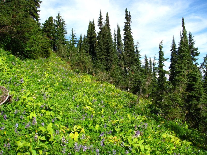
Much of the upper route to SCL is through a wonderful old-growth forest of moderate sized trees and very little undergrowth that only recently shed the last of its winter snow. We took a moment to stop at SCL to orient ourselves for the next section of un-trailed travel. We would travel through meadow/ridge systems towards the prominent rocky sub-peak that frames the north side of the East Rainbow Glacier in the background.


From SCL, the way was straight-forward with some gentle undulations. The elevation was perfect for False Azalea growth, but conditions were dry so footing was more secure. We quickly came to a series of meadows with strips of trees in between that made for somewhat better travel. Generally, the False Azalea was less thick in areas of deeper shade.


We were pleased that the meadows were fairly well-connected. We did sometimes have to lose nearly 100m elevation and then rise up again, but usually the drops and climbs were much less. At the same time there was lots of meadow variety to keep us looking around the next corner.


Our goal was to find a treeline route that didn't get into scrambling terrain, so we contoured below the big granite NE outlier of the East Glacier and dropped into an obvious basin east of Rainbow. We only dropped about half-height before traversing across and heading south on a climbing contour towards the ESE Ridge of Rainbow.


The route was quite straight-forward and the talus well-behaved. We joined the mountain-bike trail on the top of the ESE Ridge and wandered downtrail to eventually connect with the Flank Trail and our previous ascent route.

We took about eight hours on this reconnaissance, taking lots of photos and trying to find the best route. Would be a quick trip with a trail in place. Looked like we did about 2000m of vertical gain with all the ups and downs.

The following day, the upper part of the route would have been under snow for the second time in the past 10 days. Today it got walloped with snow and wind!


Spot track added to show lollipop route:


Fun is where you make it...
msulkers is offline  
Quote
Sponsored Links
Advertisement
 
post #2 of (permalink) Old 09-26-2011, 10:43 PM
High on the Mountain Top
 
Join Date: May 2006
Location: North Vancouver, BC, Canada.
Interest: Having Fun!
Posts: 1,084
Default

Very Cool, It is beautiful up there. That MTB Trail is actually a Trials Motor Bike Trail that was built there a long time ago. The deep ruts are actually dh mountain bikers who have heli dropped that trail. The trail builder has re-routed some sections because of this. I was up there a week and a half ago with some trials riders..so fun. Nice report and cool loop the way you did it!
norona is offline  
post #3 of (permalink) Old 09-27-2011, 07:13 AM Thread Starter
High on the Mountain Top
 
Join Date: May 2005
Location: Whistler, BC, Canada.
Interest: Exploring the Coast Mountains and surrounding ocean waters in all seasons.
Posts: 1,573
Default

Yes, Dave, the original trail on the ESE Ridge is the trials bike trail. The heli-drops years ago definitely led to some serious erosion, but someone has done a little work re-routing a few ditches in places. The terrain would be great for a real hiking trail as well, which could easily be routed to avoid the trials trail.

As you saw when you were up there last, most of the snow was gone. Of course, after the past two days, it's back again!
msulkers is offline  
Sponsored Links
Advertisement
 
post #4 of (permalink) Old 09-27-2011, 09:41 AM
High on the Mountain Top
 
Join Date: May 2006
Location: North Vancouver, BC, Canada.
Interest: Having Fun!
Posts: 1,084
Default

Yes it was a wicked ride up and down and trials and hiking go very well together. We cruised up to the heli drop then through the snow and rock and Spenser a much better rider than me made it almost 3/4 way up Rainbow. I went swiming in the small ponds in the rock sections, it was awesome!!!

norona is offline  
post #5 of (permalink) Old 09-27-2011, 10:35 AM Thread Starter
High on the Mountain Top
 
Join Date: May 2005
Location: Whistler, BC, Canada.
Interest: Exploring the Coast Mountains and surrounding ocean waters in all seasons.
Posts: 1,573
Default

You are, by the way, not the first swimmer this year in that pond! A couple of former students were up just the week before you and swam under part of the ice wearing a helmet and GoPro. Good fun.

Great to see you guys enjoying yourselves up there. Definitely a beautiful area.
msulkers is offline  
Reply

Thread Tools
Show Printable Version Show Printable Version
Email this Page Email this Page


Posting Rules  
You may not post new threads
You may not post replies
You may not post attachments
You may not edit your posts

BB code is On
Smilies are On
[IMG] code is On
HTML code is Off
Trackbacks are On
Pingbacks are On
Refbacks are On

 
For the best viewing experience please update your browser to Google Chrome
 

Search Engine Optimization by vBSEO 3.6.1