There are lots of Williams Peak TRs on this site, so this will mainly be an update on conditions and route options. My dad, my sister and I left the parking lot at the Williams Ridge trailhead at about 7:30 on Sunday August 7 after scoping the south side of the peak from a bit further up the Chilliwack River road. Mosquitoes were pretty annoying all the way up to the ridge and most of the way to the knoll above treeline, where the horseflies took over. The little creek near the top of the steep climb to the ridge is running, so there is the prospect of water on the return trip.
There is no snow to speak of until you reach the talus bowl below Williams Peak, and even there it is getting patchy. The route through this bowl is well marked with flagging and cairns -- the key is dropping down the heathery gully at the first knoll as seen on several other TRs on CT. Don't drop too far down, though. Look for flagging that contours below bluffs into the heart of the bowl.
On the way up we followed a steep rocky gully from the talus bowl up to the southwest ridge of Williams Peak, as shown in Matt Gunn's book. I don't recommend this. Instead, cut back to the right on an easy-angled bench/ramp (snow covered now) and reach the ridge somewhat lower down. The gully we took up is very loose and gravelly. On our return (mainly to avoid having rocks kicked down on us) we took the snowy bench/ramp, and it was just as quick and a lot cleaner. This can be seen in the photo below (see photo description for more detail).
1. Talus bowl below Williams Peak.

After reaching the southwest ridge we contoured past the south face gully described in Matt Gunn's book to the broad ridge on the far side of the gully. There is still some snow in the south face gully, but it has melted away from the right side, leaving a snow-free heather plod to the summit. Another party including a dog were able to climb this gully without trouble. We chose the rocky ridge to the climber's right side of the gully for a more enjoyable scramble. As a few others have noted on this site, this ridge is easy Class 2 and Class 3, with almost no exposure. On the way up we climbed some fun walls and slabs between heathery ledges, but this really isn't necessary. If you look hard enough and zigzag you can find an almost hands-free route up this ridge. I recommend this ridge as an easier, less exposed alternative to the ridge that is to the climber's left of the south gully, and a more fun route than the grassy south gully itself. Besides, as we found out on descent, rocks can come down the south gully with some speed.
2. Looking up the upper half of the south gully, showing current extent of snow patches.
3. Fun scrambling on the ridge to the climber's right of the south gully.
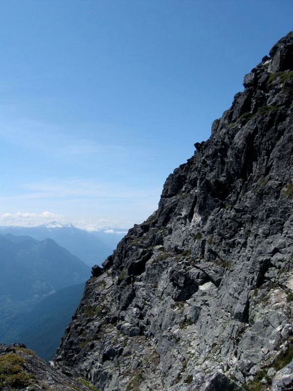
4. Looking down the broad ridge we climbed.
5. Looking across the south gully to the steeper ridge on the climber's left side of the gully.


Great views, no bugs, and nice temps made the summit was a very pleasant place, and we hung out for quite awhile, joined by 2 other parties. One of these took the south gully route, and the other took the steeper Class 3 ridge left of the gully. So, 3 parties summited Williams on Sunday, each taking a slightly different route.
6-8. Summit shots of me, my sister and an old guy.


On the way down I took the quicker south gully route, while my dad and sister took the ridge we came up. The meltwater at the bottom of the snow patch in the gully saved us from dehydration. There is very nice cold water available for the next couple of weeks, but later in the season pack a lot of water! Be careful of rockfall in the gully if there are other climbers above.
9. Starting down the south gully.

The mosquitoes waiting for us below treeline on Williams Ridge were happy that our Deep Woods OFF! had sweated off, and they drove us down the steep trail to the truck at a jog. We took about 6.5 hours up, an hour on the summit and about 3.5 hours down, for a total of 11 hours return. A long day but a satisfying summit.
10. Looking back on a satisfying summit.


 Williams Peak conditions and route notes


 Your Privacy Choices