AB Nor = Alberta Rockies North (Jasper & Willmore) Swarming Bugs and Wildfire Haze: Enter Tonquin - ClubTread Community

User Tag List

 3Likes
  • 2 Post By zeljkok
  • 1 Post By zeljkok
 
LinkBack Thread Tools
post #1 of (permalink) Old 07-18-2021, 12:08 AM Thread Starter
Summit Master
 
zeljkok's Avatar
 
Join Date: May 2009
Location: Anywhere except social media
Posts: 5,435
Default Swarming Bugs and Wildfire Haze: Enter Tonquin

From Patton&Robinson Canadian Rockies Trail Guide
Quote:
.. but in the midst of summer when mosquitoes and horseflies are swarming and trails have been churned to mush by horses, Tonquin can resemble backpacker definition of hell
I've been to Tonquin before, but it was out-and-back Astoria dayhike. I knew I'd return for overnight as it is one of classic Rockies backpacks. But why now, with knowledge of above warning? Part of me that found second wind in life by exploring great outdoors wants to experience all sides of the story. So I did 4 day, 3 night through mid-July backpack:


  • Day 1) Park at Astoria Trailhead, cycle to Portal Trailhead, Hike to Maccarib campground
  • Day 2) Dayhike to Moat Lake/Tonquin Pass then Maccarib meadows in the evening. 2nd night at Maccarib campground
  • Day 3) Move camp from Maccarib to Clitheroe, then dayhike to Outpost Lake via Surprise Point/Chrome Lake
  • Day 4) Hike out via Astoria River


And bugs? Well, there are bugs and then there are Tonquin bugs. I don't think I've experienced anything like this before; it needs to be seen to be believed. Endless swarms, often one of top of the other. Leave tea cup uncovered, within a minute at least 10 mozzies will have drowned. When you open tent zip to get in/out, regardless how fast you are, dozen will get in & you have to chase them out then unless you want to be bitten overnight (I woke up to dots of blood on tent floor in Maccarib). Bug spray doesn't do squat. For the first time ever I was forced to wear mosquito net: Don't go to Tonquin without it in summer!


But this might paint wrong picture; Tonquin is spectacular. 7km drop from Maccarib Pass is one of nicest alpine meadowlands I've ever seen. Amethyst outlet by Surprise point (where most classic Tonquin photos are taken) is simply spectacular. I know now I'll be back on a crisp Autumn week for sole photography purposes as potential for landscape photographer is immense.


Few photos, which are all poor quality but it couldn't be helped as haze from BC wildfires pretty much obscured everything entire time:


Click image for larger version

Name:	maccaribpasspano.jpg
Views:	55
Size:	407.9 KB
ID:	287366
[Looking back from Maccarib Pass, real highlight. That is Old Horn Mtn upper right, and Maccarib Mtn to its left. Further left in the distance even Edith Cavell is poking out. This was the clearest day of the 4]


Click image for larger version

Name:	moatmeadowpool.jpg
Views:	64
Size:	678.7 KB
ID:	287368
[Delightful alpine meadow on trail leading to Tonquin Lodge and onto Moat Lake. Bugs were tolerable here & even managed a nap after lunch lying in grass]


Click image for larger version

Name:	maccaribmeadows.jpg
Views:	58
Size:	701.7 KB
ID:	287364
[Maccarib Meadows trail end above Maccarib campsite. Mt. Clitheroe in the distance]


Click image for larger version

Name:	amethystmeadowspano.jpg
Views:	66
Size:	330.5 KB
ID:	287360
[Classic boardwalk near Amethyst campground, with Ramparts in the background. Just imagine how spectacular photo one could make here with right conditions]


Click image for larger version

Name:	chromelake.jpg
Views:	58
Size:	466.3 KB
ID:	287362
[Chrome Lake. Note: Bridge leading to Eremite valley / Arrowhead lake is out (partially submerged)]


Click image for larger version

Name:	surpriseoutletpano.jpg
Views:	57
Size:	245.7 KB
ID:	287372
[Amethyst Outlet ~1km from Surprise Point campground -- which is for me by margin the nicest of Tonquin campgrounds, even if Amethyst is quite nice too]


Total loop for Portal - Astoria direction (without dayhikes) comes to ~45km with +1290m (elev. gain) -1055m (elev.loss) so it is even doable as dayhike; I also know trail runners frequently do it too, but backpack is the only way to go for me. GPS Map and Elevation Profile
Click image for larger version

Name:	tonquinvalleymap.jpg
Views:	56
Size:	392.4 KB
ID:	287374
Click image for larger version

Name:	tonquinvalleyelevation.jpg
Views:	58
Size:	197.8 KB
ID:	287376

In subsequent posts I will provide more details, including discussion about often asked transit between trailheads.


Detail report on personal site incl. GPS track download here; It will get updated with better photos on subsequent visits.
martin and solo75 like this.

Last edited by zeljkok; 08-06-2021 at 07:09 PM.
zeljkok is online now  
Quote
Sponsored Links
Advertisement
 
post #2 of (permalink) Old 07-18-2021, 02:15 PM
Headed for the Mountains
 
VicB's Avatar
 
Join Date: Dec 2010
Location: Calgary, AB, Canada.
Posts: 170
Default

I've made three backpack trips into the Tonquin, all via Astoria, and one day hike to Maccarib Pass and back. I concur re the bugs but the mountain vistas and meadows are worth it. The first trip in we encountered a grizzly near the Surprise Point campground. Later, one of our gang hand caught a large trout from the stream flowing from Amethyst Lakes. His bare arm was severely pierced before he succeeded.

In '78 I made one of the best, with Great Divide Girl's mom, a five day, four night, bug-free, late September backpack loop. With no information other than the topographic map we started at Astoria and made our first camp beyond Verdant Pass high above the Whirlpool Valley. Next day we side-hilled to a camp in the valley east of Angle Peak. Next day we hiked up the valley to the pass leading to Eremite Valley.

Click image for larger version

Name:	Scan20001 2.jpg
Views:	69
Size:	334.2 KB
ID:	287390
Looking up Eremite Valley in '94. I think we crossed the pass on the left.

The next day we backtracked a bit to cross a rough pass between the south outlier of Thunderbolt Peak and Campus Peak to a camp in the Campus Pass meadows. Later that day I made a solo first ascent of "Freshman Mountain". That evening we enjoyed watching a herd of caribou in the meadows. On the final day, we went through Campus Pass, past Beryl and Buttress Lakes to complete the loop at the Verdant Pass trail. It's a loop I'd be surprised if anyone else has done but maybe someone reading this will be inspired.

Here's a few photos from a '94 trip. We stayed at the ACC hut and climbed Outpost, Memorial, Surprise Point, McConnell and Clitheroe.

Click image for larger version

Name:	Scan2.jpg
Views:	62
Size:	373.1 KB
ID:	287392
The Ramparts. Surprise Point is the lower dark peak in the foreground.

Click image for larger version

Name:	Scan20002.jpg
Views:	58
Size:	343.3 KB
ID:	287394
Amethyst Lakes beyond Surprise Point from the summit of Outpost. Outpost Lake and the Wates-Gibson ACC hut below.

Click image for larger version

Name:	Scan20006.jpg
Views:	72
Size:	404.2 KB
ID:	287396
Surprise Point summit, Outpost and Memorial behind.

Click image for larger version

Name:	Scan20003.jpg
Views:	61
Size:	466.9 KB
ID:	287398
The back side of the Ramparts, Redoubt, Dungeon and Oubliette from the summit of McConnell.

Click image for larger version

Name:	Scan20004.jpg
Views:	58
Size:	533.7 KB
ID:	287400
Caribou in the meadows below Clitheroe.

Last edited by VicB; 07-18-2021 at 02:39 PM.
VicB is offline  
post #3 of (permalink) Old 07-18-2021, 06:22 PM Thread Starter
Summit Master
 
zeljkok's Avatar
 
Join Date: May 2009
Location: Anywhere except social media
Posts: 5,435
Default

Quote:
Originally Posted by VicB View Post
...
In '78 I made one of the best, with Great Divide Girl's mom, a five day, four night, bug-free, late September backpack loop. With no information other than the topographic map we started at Astoria and made our first camp beyond Verdant Pass high above the Whirlpool Valley....

Wow, this is separate, very advanced Tonquin Trip Report. I was wondering about scrambling, but except for Maccarib and Clitheroe have no beta. Wates-Gibson Hut was closed (I'll get to it in later post), but it's presence signaled peakbagging opportunities. That whole south corner (Eremite, Campus etc) just begs to be explored. Ditto vast ridge system above Maccarib Meadows. Next time, Sep timeframe, think I'll quickly hike in via Astoria, make multi-day base at Surprise Point Campground and go exploring/photographing, finally loop hike out via Chrome lake; incidentally heard talk about bridge being out there too
zeljkok is online now  
Sponsored Links
Advertisement
 
post #4 of (permalink) Old 07-18-2021, 08:06 PM Thread Starter
Summit Master
 
zeljkok's Avatar
 
Join Date: May 2009
Location: Anywhere except social media
Posts: 5,435
Default Astoria - Portal Trailhead Transport Logistics

Transport between Astoria and Portal trailheads is often discussed topic for those planning through hike. Obviously easiest way is if you are with group that has 2 cars. It will take ~20-25min of driving (1-way). Cavell Road is narrow at spots with several sharp switchbacks in lower part, but Marmot Road is wide open. Problem is if you are solo, or have just 1 vehicle. So here is bit of discussion on that topic & what worked for me.


Biggest, often repeated advice I can give is: Do NOT leave transport problem for the end when you are all tired and beat after several days in back-country, begging for food and shower. Always, always hike towards your vehicle; it might seem like a drag in the beginning when you are aching to get going, but you'll be really thankful at the end.


Three different approaches are possible:


1) Hitch-hiking. Keep in mind that Cavell Road is far busier than Marmot road, and you might need two different rides. This is least viable option in my mind


2) Taxi. Portal trailhead has cell coverage, Astoria doesn't. So if needing a ride from Astoria, you might need to arrange in advance. There is also $$ question; think someone told me it will take ~$100 CAD

3) Cycling. Most self-reliant which is always the best choice, but there are issues, such as:


  • Astoria trailhead is higher and cycling Cavell road uphill will be huge grunt
  • Cycling for at least an hour before the hike with heavy overnight backpack will require additional energy
  • Stashing of bike / backpack. You are likely not to cycle with overnight pack on your back & that means backpack will need to be left unattended at starting trailhead for over an hour. Also bike will have to be left 'out there' for several days. Now Jasper is not BC and thefts are not as common, but there is still a risk
Some people use combination of cycling and hitch-hiking. In Maccarib campground I met French girl; she had bike stashed at Portal where she planned to finish. She was going to cycle Marmot Road downhill, then try to hitch-hike busier Cavell Road where chances for pick-up are higher.
---------------


Finally, this is what I did, and including some info I think only few Jasper locals might be aware off:


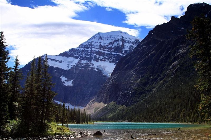
First, I drove to Portal TH, got ready then left backpack behind the toilet. (It was a risk but nobody saw me doing it, road is almost deserted and you'd have to look quite hard to find it). I took only small water bottle with me, drove to Astoria, parked then mounted a bike. You will need water, and roughly 5 min down Cavell road there is bridge with good water where I stopped and filled up, then strapped bottle on bike frame
Click image for larger version

Name:	astoriabike.jpg
Views:	59
Size:	661.8 KB
ID:	287484
Click image for larger version

Name:	astoriabikeaquila.jpg
Views:	65
Size:	714.7 KB
ID:	287482
[Aquila Peak behind the drainage with water on Cavell Road]


Ride down is great fun! Mind the switchbacks and brakes, as well as cars. Then it's ~3km on Wabasso Road which is mostly flat or even slightly downhill. Then it's up Marmot Road, and that is the problem. It was very hot day, already +30 and I was not sure I'll be able to pull it off. But just as I started up Marmot Road, almost directly opposite road sign ~100m from Wabasso Road I noticed trail entering forest. I was always suspecting hiking trail might exist there, even inquired with lobo, but he hasn't heard of any. Well, there is one and it is quite good; I think it is used by local mountain bikers. So I stashed my bike in the forest and hiked up. Basically trail climbs above south bank of Portal Creek and being with no backpack I was able to run up that trail very fast; it emerges on Marmot Road ~1km from Portal Trailhead !!

Click image for larger version

Name:	portalroad.jpg
Views:	59
Size:	649.3 KB
ID:	287480
[Remainder of Marmot road I walked to Portal Trailhead, ~1km]


In total, cycling + hiking it took just above 1 hour, spending very little energy. Backpack waited for me untouched. I highly recommend this alternative if you are not quite up to cycling Marmot Road uphill


Click image for larger version

Name:	portalth.jpg
Views:	39
Size:	728.2 KB
ID:	287478
Click image for larger version

Name:	portalthtable.jpg
Views:	66
Size:	548.0 KB
ID:	287476


Portal Trailhead, after successful bike&hike from Astoria. It was exactly 2pm at this point and ~20km hike to Maccarib Campground awaited. This is next post.
zeljkok is online now  
post #5 of (permalink) Old 07-19-2021, 06:21 AM
Headed for the Mountains
 
Join Date: Jan 2018
Posts: 114
Default

@VicB that is amazing! I've had my eye on the Astoria - Verdant pass - Eremite part of your loop for a while but I don't know when I'll get to do it if ever.

@zeljkok I took the cab - it was $100 4-5 years ago, split it with other people so not too bad.
dpdp is online now  
post #6 of (permalink) Old 07-21-2021, 06:43 AM
Hittin' the Trails
 
Join Date: Jul 2010
Location: virginia beach, Virginia, USA.
Posts: 42
Default

beautiful terrain despite the smoke. thanks for posting.
themadgaffler is offline  
post #7 of (permalink) Old 07-22-2021, 05:32 PM Thread Starter
Summit Master
 
zeljkok's Avatar
 
Join Date: May 2009
Location: Anywhere except social media
Posts: 5,435
Default Portal Trailhead to Maccarib Campground

Stats: ~20km with +800m Elevation gain, -300m Elevation loss. Most of elev.loss is on 7km hike from Maccarib Pass following Maccarib creek to campground
Click image for larger version

Name:	portal2maccaribmap.jpg
Views:	64
Size:	357.4 KB
ID:	287624
Click image for larger version

Name:	portal2maccaribelevation.jpg
Views:	62
Size:	182.7 KB
ID:	287626


Patton&Robinson state that this approach holds "definite scenic advantage" compared to Astoria trail on the other side & I'd have to agree. Initial part is quite tedious; within 5 minutes trail crosses on north side of Portal creek then settles on long steady mostly forested climb on sometimes rocky & rooty trail. But after crossing back to south side of Portal creek ~4km mark, things start improving. Trail contours east slopes of Peveril mtn, then drops to Portal campground ~9km mark. Day was very hot & I was laboring quite a bit taking frequent breaks. There were no bugs at this point yet, but after passing the campground and starting Maccarib Pass ascent swarms started and just kept getting worse and worse. However fantastic views were more than adequate compensation, and 7km hike from the Pass down Maccarib creek is one of nicest alpine hikes you will ever do. I started from trailhead at 2pm & gave myself 8hrs to campground, but was able to get by 9pm with plenty of daylight to setup camp & have dinner. Photo story:


Click image for larger version

Name:	lowerportalbridge.jpg
Views:	60
Size:	835.4 KB
ID:	287628
[Lower Portal creek bridge ~5min from the start. Creek was raging and bridge is pretty much necessary. Overall I was quite impressed about the trail; maintained bridges and signs. There were signs of horse traffic, but horses frequent more Astoria side]


Click image for larger version

Name:	upperportalbridge.jpg
Views:	49
Size:	871.0 KB
ID:	287630
[Upper Portal creek bridge ~4km mark; Peveril mtn upper left]


Click image for larger version

Name:	maccaribslidepath.jpg
Views:	63
Size:	707.5 KB
ID:	287642
[Crossing rock slides contouring Peveril Mtn. Portal creek in in valley below, and Aquila Mtn on the other side]


Click image for larger version

Name:	maccaribpassascentback.jpg
Views:	60
Size:	681.6 KB
ID:	287634
[Ascending Maccarib Pass in great alpine environments. Maccarib Mtn. just poking upper right]


Click image for larger version

Name:	maccaribpostvertical.jpg
Views:	83
Size:	683.7 KB
ID:	287638
[Parks Sign Post at 2210m; it was ~7pm at this point & I knew I'd be able to cover remaining 7km to Maccarib campground ahead of schedule]


Click image for larger version

Name:	maccaribramparts.jpg
Views:	61
Size:	490.5 KB
ID:	287640
[First view of already hazy Ramparts. Smoke was still acceptable but thick haze rolled in overnight the next day and remained for rest of the trip unfortunately]


Click image for larger version

Name:	maccaribpassmeadowsback.jpg
Views:	83
Size:	668.3 KB
ID:	287636
[Looking back towards Maccarib Pass while crossing Maccarib Creek]


Click image for larger version

Name:	maccaribmtnpass.jpg
Views:	61
Size:	677.4 KB
ID:	287632
[Nice shot of Maccarib Mtn while descending down the valley. It is definitely possible to trash up to skyline ridge just right of the peak, then drop down wooded slopes on the other side & intercept Astoria trail somewhere between Clitheroe and Switchback campgrounds]


Maccarib camp is nice and water source (Maccarib Creek) is right below the camp. 8 quite wide tent sites, 2 picnic tables in cooking area, numbered metal food lockers and 3 open-air toilets. There is semi-open view of Ramparts from cooking area. Only 3 sites out of 8 were occupied - so campground was half empty on first night, despite showing as all booked on Parks Reservation site. I can not understand why people book and then don't cancel if they decide not to go. There was also quite a bit of 'campground switching' -- on 2nd night I had 2 French guys pitching up tent at my site. There was enough space so I didn't care too much, but I did ask them why did they do it -- and answer was "We have reservation at Clitheroe, but decided to camp here to be with our friends". These are kind of things you have to deal with on these ultra-popular backpacks; in addition on 2nd night after I got back from my day-hikes I found food all over the tents of some Asian group; they decided to eat right by their tent, then crawl in to hide from mosquitoes. This made me quite nervous and although I generally mind my own business, I had to intervene as there were grizzly sightings the same day up in Maccarib Meadows.


Next day after quite good sleep I went dayhiking to Moat Lake/Tonquin Pass, and then Maccarib Meadows in the evening. This will be the next post.
zeljkok is online now  
post #8 of (permalink) Old 07-25-2021, 05:25 PM Thread Starter
Summit Master
 
zeljkok's Avatar
 
Join Date: May 2009
Location: Anywhere except social media
Posts: 5,435
Default Moat Lake and Maccarib Meadows Dayhike

After sleeping better than expected I made my way through swarms of mosquitoes to food lockers, and after making breakfast discovered nice little bench just below picnic tables; it has good view of Ramparts, but alas haze obscured most of it & I knew it was not likely to get clear anytime soon
Click image for larger version

Name:	maccaribcampbench.jpg
Views:	49
Size:	843.7 KB
ID:	287740

Still, after crossing back Maccarib Creek and hiking few minutes along main artery bugs somewhat eased; they never disappeared but it was tolerable. Made it to signed junction and took right towards Tonquin Lodge / Moat Lake - Tonquin Pass. This is very enjoyable walk across open meadows with boardwalks and Amethyst Lakes with towering Ramparts behind could be seen
Click image for larger version

Name:	tonquinlodgeboardwalk.jpg
Views:	48
Size:	437.3 KB
ID:	287748

After stopping for early lunch by some very photogenic ponds I came to Tonquin Lodge. Horseflies were horrible here & I watched poor horses trying to fend swarms attacking them; poor things couldn't stand still and constantly walked in clear distress. Owners had two barrels with smoke but it didn't seem to help much. At lodge had chat with housekeeper, learning they are just starting to get guests after Covid lockdowns. Package includes full board; cabin and meals. Price? 330 cad/night (and you still have to walk - or horse ride - but no magic carpet will get you there).

Click image for larger version

Name:	tonquinlodge.jpg
Views:	58
Size:	663.6 KB
ID:	287750

Below lodge was very neat boat dock; on a clear day it would be great joy to go for a paddle in Amethyst Lakes. I was also told there is plenty of fish
Click image for larger version

Name:	tonquinlodgeboatdock.jpg
Views:	54
Size:	534.5 KB
ID:	287752

Back on trail, I dropped towards some uneven terrain then crossed rather vast meadow heading towards Moat Lake. Trail is flagged and cairned, but periodically disappears. Direction is obvious though. Takes ~40min from Tonquin Lodge. Moat Lake is very nice, but again haze ruined the views. I made my way halfway around north side of the lake and discovered couple of canoes stashed there; bugs were not bad so I made me a nest there and even fell asleep for half an hour. There didn't seem to be any trail beyond so if you are bound for Tonquin Pass, you are likely to step through much of swamp and bog. I was intrigued by Tonquin Hill rising above & I'd be willing to bet there is acceptable trail leading to the top, but simply had no energy - or will - considering heat and haze.
Click image for larger version

Name:	moatlake.jpg
Views:	57
Size:	559.3 KB
ID:	287746


Back at Maccarib camp I made early dinner. Camp swarmed up and was full, so looking for some solitude I decided to hike up Maccarib Meadows behind the camp; posted sign says 2.2 km, but I think there is more. Nearby is memorial to Percy Goodair, park warden that perished here from grizzly bear attack sometime in last century
Click image for larger version

Name:	percygoodair.jpg
Views:	50
Size:	892.3 KB
ID:	287744

Trail ends in rather superb viewpoint gaining ~200m vertical above camp, but views were totally obscured. I still bundled to cover from mozzies and sat in grass for 30min imagining the views that might be. There is much room for further exploration here; one could simply head further up exploring vast ridge system above and I bet views get better the higher you go
Click image for larger version

Name:	maccaribmeadows2.jpg
Views:	55
Size:	498.0 KB
ID:	287742

Tomorrow morning I moved camp from Maccarib to Clitheroe, then went dayhiking to Surprise Point/Chrome and Outpost Lakes. This will be next post
Trail Talk likes this.

Last edited by zeljkok; 07-25-2021 at 05:27 PM.
zeljkok is online now  
post #9 of (permalink) Old 07-25-2021, 06:23 PM
Headed for the Mountains
 
Join Date: May 2012
Location: Edmonton, Alberta, Canada.
Interest: Adventure travel
Posts: 336
Default

Great TR, brings back memories of many pleasant trips to the Tonquin. Many years ago, 3 of us skied the circuit from Portal to Cavell parking lot in 10 1/2 hours. I don't recall much about the scenery on that trip, excepting the lack of any due to a whiteout on Maccarib Pass, but its my best memory

Trail Talk
"Retired but not yet tired"

Last edited by Trail Talk; 07-25-2021 at 06:36 PM.
Trail Talk is offline  
post #10 of (permalink) Old 07-28-2021, 06:28 PM Thread Starter
Summit Master
 
zeljkok's Avatar
 
Join Date: May 2009
Location: Anywhere except social media
Posts: 5,435
Default Surprise - Outpost Dayhike

Next day after packing up Maccarib Camp I made my way on main Artery to Clitheroe, with brief stop at Amethyst camp -probably most popular Tonquin campground- for water break. Amethyst was also very buggy, but very nicely laid out & I could see why people like to stay here. Crowd could be spotted at Lake shore; I was told later they spotted caribou. Past some boardwalks trail turns east and climbs back into the forest reaching Clitheroe in about 2km. Contrary to Amethyst Camp, Clitheroe is probably least popular. Reason -- it is entirely in the woods so you get no views. Plus - you might be able to find space here when other camps are fully booked. Bugs were horrible and I did entire chore of setting up camp & having lunch with mosquito net on. Also water was quite far away - you need to walk back for ~200m to main trail, then another ~100m to creek crossing. I simply filled my cooking pot & had enough for tea later on & breakfast next morning.


After lunch, I headed down the trail towards Surprise Point passing Tonquin Ranger cabin along the way. This cabin is situated in a very pretty meadow with great views of the Ramparts -- I say over and over: Park Rangers know where to build their cabins! Stopped briefly at the porch, then continued down towards Surprise. This is unbelievably scenic area, and all classic shots of Tonquin you see floating on Internet are taken by outlet, which was very nicely bridged. Surprise Point is for my money best Tonquin campground; only drawback I could find was that water was quite far away. Either walk back to Amethyst outlet, which was almost 1km away, or take still water from small lake below which needs to be boiled. I was also surprised that there were only 4 tent pads! And then abundance of picnic tables; think every tent site had one to itself in cooking area! When I come back to Tonquin for photography I plan to stay in Surprise for several nights; it can easily be reached in 6-7 hrs from Astoria trailhead, and there is also loop return option.


Click image for larger version

Name:	surpriserangercabin.jpg
Views:	56
Size:	715.1 KB
ID:	287784
[Ranger Cabin below Clitheroe]


Click image for larger version

Name:	surpriseoutletpano.jpg
Views:	44
Size:	245.7 KB
ID:	287786
[Pano at Amethyst Lake outlet; this is just a phenomenal spot when skies are clear. Surprise point is less than km away]


Beyond Surprise Camp trail descends for quite awhile towards Eremite Valley Junction. It is big rooty but not terrible, however when dayhiking from Clitheroe or Surprise you need to reascend all this on return. Reaching valley bottom there was Eremite / Outpost / Astoria junction
Click image for larger version

Name:	outpostjunction.jpg
Views:	86
Size:	556.7 KB
ID:	287790


Note: If you plan on seeing Chrome Lake (and you should, as it very pretty) you need to walk for ~5min in Astoria direction. I was also told that some bridge in that direction was washed out & it was not possible to connect all the way, but this info was not verified. Eremite trail soon comes to another junction and I continued towards Outpost Lake and Wates Gibson Hut. Some hikers at Surprise camp told me (and shown photos) of submerged bridge in Eremite/Arrowhead direction so it was not even possible to head there in this time; I'll save it for fall, clear skies trip. Several crossings of Outpost creek were also quite high, but not an issue. Final rise to Wates Gibson hut gains more elevation than expected. Hut itself is quite nice. There was nobody there; after inspecting the environment, I hiked to boat dock and had a snack.


Click image for larger version

Name:	outpostcrossing.jpg
Views:	31
Size:	743.6 KB
ID:	287794
[Bridged crossing of Outpost creek; almost overflowing]


Click image for larger version

Name:	wghut.jpg
Views:	43
Size:	851.5 KB
ID:	287798
[Wates-Gibson ACC Hut; very nice, there was nobody in & it was locked. I peeked through the window and saw standard setup. Outhouse was behind and since it was open I used it]


Click image for larger version

Name:	wgwindowladder.jpg
Views:	47
Size:	602.3 KB
ID:	287800
[Wates-Gibson Hut detail]


Click image for larger version

Name:	wgwoodshed.jpg
Views:	40
Size:	787.5 KB
ID:	287802
[Woodshed behind the Hut with plenty of firewood]


Click image for larger version

Name:	nowashsign.jpg
Views:	42
Size:	505.2 KB
ID:	287796
[Interesting sign by the Hut! Make your own conclusions]


Click image for larger version

Name:	outpostpano.jpg
Views:	47
Size:	230.7 KB
ID:	287788
[Outpost lake from the dock below the Hut]


Noticing something on far shore I decided to take a look: Good trail leads around the lake, and that feature was actually old fireplace. It looks like there was a cabin there at some point, and now all that's left is this fireplace.

Click image for larger version

Name:	outpostfireplace.jpg
Views:	33
Size:	856.2 KB
ID:	287792


If you follow trail past the fireplace to far end of the lake, you will be able to spot small waterfall draining Outpost Lake. After inspecting it, I returned & decided to take a dip in the lake. Bugs were horrible so the trick was to take your clothes as fast as you can and just dive in. Then when you get out you have about a minute while still wet before they come back at you. Refreshing - and interesting - experience.


I then hiked back up to Surprise Point (with brief detour to Chrome Lake) and onto Clitheroe for the night. Next day after packing up I hiked to Astoria trailhead where parked car waited. This will be the last post.
zeljkok is online now  
post #11 of (permalink) Old 07-30-2021, 07:40 PM Thread Starter
Summit Master
 
zeljkok's Avatar
 
Join Date: May 2009
Location: Anywhere except social media
Posts: 5,435
Default

Last post
Did not sleep well in Clitheroe that night; when you backpack for several days in quite hard conditions (heat, haze, bugs) it eventually starts wearing down on you. Still rested enough, I packed up camp & was on trail by 10am. What motivated me was knowledge that bugs will likely vanish as soon as I start switchback descent on Astoria trail; and they did. Chatted with some in-bound hikers & told them to get ready. After descending down to valley bottom below Old Horn mountain hiking became downright enjoyable. Took extended break in horse camp ~10min before Wates-Gibson junction & enjoyed meal for first time in several days without having to swat any bugs. Weather was changing and even few raindrops fell, but not enough to impact the haze -- that is incidentally blanketing the Rockies even now 2 weeks after. Really picked up pace after crossing Astoria River for one last time &starting last leg to Cavell lake and Astoria trailhead, passing Verdant Pass junction along the way. Photo story:


Click image for larger version

Name:	astoriaswitchbackmeadows.jpg
Views:	33
Size:	645.0 KB
ID:	287850
[Meadows at Switchback campground junction, with one last look to almost completely obscured Ramparts. This was also the point where I turned back on my Tonquin dayhike several years ago, so I was now in familiar territory, so to speak]


Click image for larger version

Name:	astoriaswitchbackslide.jpg
Views:	29
Size:	743.3 KB
ID:	287852
[Trail switchbacking huge rock slide below Old Horn mountain above. By this time there was no mosquitoes at all!]


Click image for larger version

Name:	astoriarockslidecrossing.jpg
Views:	35
Size:	721.7 KB
ID:	287846
[Crossing the Rock Slide, with sign warning hikers not to linger due to unstable slopes]


Click image for larger version

Name:	astoriaslide.jpg
Views:	25
Size:	752.9 KB
ID:	287848
[Another shot of that slide; Jasper area is in general known for unstable bouldery slopes & in my scrambling days I crossed quite a few around here. In winter there would be some avalanche danger here as well, but I am not sure if ski trail goes this way or stays lower in the valley]


Click image for larger version

Name:	astoriahorsecampshore.jpg
Views:	31
Size:	665.8 KB
ID:	287844
[Lunch break at Horse camp which was really nice, with bench and beautifully situated by Astoria River. Even dished out a stove and boiled water for second coffee here]


Click image for larger version

Name:	astoriawgjunction.jpg
Views:	30
Size:	692.4 KB
ID:	287856
[Wates-Gibson / Chrome Lake junction. Next time I plan to hike this trail for sure for loop of a sort]


Click image for larger version

Name:	astoriawgbridge.jpg
Views:	36
Size:	792.0 KB
ID:	287854
[Bridge over Astoria River at WG/Chrome junction. I was told that further up some bridge before Chrome lake was washed out & travel was difficult]


Click image for larger version

Name:	astoriabridge.jpg
Views:	39
Size:	799.1 KB
ID:	287838
[Last bridge over Astoria River, already past Astoria campground and starting last leg to Cavell Lake]


Click image for larger version

Name:	astoriagrouse.jpg
Views:	24
Size:	713.2 KB
ID:	287842
[Only wildlife I saw in 4 days, near Verdant Pass junction]


Click image for larger version

Name:	astoriacavelllake.jpg
Views:	35
Size:	622.4 KB
ID:	287840
[Cavell Lake outlet; this is such a fantastic viewpoint normally, but not on this day due to all the smoke/haze. This is now it looks normally when air is clear]


Was able to cover this last leg of ~18km in less than 5 hrs, which included 30min of breaks so I did quite good; super trail (and thoughts of cold beer in Jasper) had something to do with it! Clitheroe to Astoria Map and Elevation Profile:
Click image for larger version

Name:	clitheroe2astoriamap.jpg
Views:	35
Size:	361.9 KB
ID:	287834
Click image for larger version

Name:	clitheroe2astoriaelevation.jpg
Views:	35
Size:	138.4 KB
ID:	287836


Bicycle was waiting right where I left at start of Marmot Road, and after extended A&W pig-out (and beer!) in Jasper I drove down the Icefields. Overall with mixed feelings; wonderful adventure in iconic Rockies area was blanketed by dismal air quality/haze; at the end of the day mosquitoes are just a nuisance, but lack of scenic views and ability to take pics did bother me. I will be back, this time waiting for right conditions, which is likely second half of September timeframe.

Last edited by zeljkok; 07-30-2021 at 07:46 PM.
zeljkok is online now  
Reply

Thread Tools
Show Printable Version Show Printable Version
Email this Page Email this Page


Posting Rules  
You may not post new threads
You may not post replies
You may not post attachments
You may not edit your posts

BB code is On
Smilies are On
[IMG] code is On
HTML code is Off
Trackbacks are On
Pingbacks are On
Refbacks are On

 
For the best viewing experience please update your browser to Google Chrome
 

Search Engine Optimization by vBSEO 3.6.1