Great Divide Ski Traverse (North/Central Sections) - ClubTread Community

User Tag List

 
LinkBack Thread Tools
post #1 of (permalink) Old 05-24-2014, 12:32 PM Thread Starter
Hittin' the Trails
 
Join Date: May 2013
Location: Edmonton, Alberta, Canada.
Posts: 23
Default Great Divide Ski Traverse (North/Central Sections)

I think this is actually the thread I've posted by myself on here (normally Steven is really quick about putting up trip reports before I can get to them ) and it is a big one. Long story short a group of four Jake (Jasper), Liam (Jasper), Meghan (Revelstoke) and I (Edmonton) had been planning on giving The Great Divide Ski Traverse (described in Chic Scott's book going from Jasper to the Great Divide Lodge west of Lake Louise) a go this spring. This trip had been a long time in the pipes including four multi-day food cache-placing treks leading up to the big trek itself. Due to several reasons (which I briefly outline in the TR) Meghan and I only ended up completing the North and Central portions of the traverse (Jake and Liam are still out there sorting out the Southern portion with some modifications to the route). As such, my part of the trip only covers the section of the traverse from Jasper to the Columbia Icefield.

I have a really long trip report on my site if anyone is interested in the whole tale of adventure, adversity, and assorted hijinks (you might want to grab a coffee before diving into the full TR, it is quite a long read). Alternatively, if you would just like some pretty pictures of less travelled areas in the North Section some are attached below. I'm writing the North and Central Sections separately, the Central one might take a bit of time to sort out. Suffice to say, this was certainly the most ambitious thing I have ever attempted and overall it proved to be a great adventure with excellent folks.

Summary For North Section:
Full TR: http://benthereclimbedthat.ca/Outdoors/2014_GDT_North
Trip Duration: 16 days from Portal Creek Trailhead (part way up the road to Marmot Basin in Jasper) to Mount Clemenceau (including 4 bad weather tent-bound days)
Total Distance by GPS: 122 km
Ascended Peaks: Mount Clemenceau (via W face as described in the 11000ers book)

Trip Report In Brief:
We basically followed the route as recommended by Chic Scott in Summits and Icefields starting off from the Portal Creek Trailhead in Jasper and carrying on towards the South via Oldhorn Col - Needle Col - Scott Glacier - Serenity Glacier - Wood River - Clemenceau Creek.

The guidebook directions give a good feel for the rough route but there was still a fair bit of fine map/gps navigation needed. Snowpack conditions were usually consistent with spring weather (icy in the morning, slushy in the afternoon) so we gradually adjusted ourselves to 'alpine time' getting up at 3 or 4 am each morning. For our trip, the 'crux' of the Northern Section was gaining the Hooker Icefield via Scott Glacier. When we first arrived at Scott Glacier conditions were tropical (wading in glacial runoff to cool-off type of temperatures) which lead to avalanche and seracs coming down off the glacier all night and all of the next day. After that a storm rolled in throwing down rain (with more avalanches and rockfall) and blocking off views for the next three days (all the while our fixed food reserves were dwindling even with frugal rationing). After finally sorting out the Scott Glacier under marginal conditions the rest of the North Section went fairly well. One thing to remember if going for this route is to not underestimate travel times between Wood River and Clemenceau. We only managed 7km one day due to the dense bush, and repeated travel through avalanche debris. Once on the Clemenceau Icefield all of the suffering seems worthwhile! For ascending Mount Clemenceau we followed the route described in the 11000ers book which ended up being surprisingly straightforward with our conditions (we did end up making one blunder at about 3200m trying to avoid a very steep slope going climbers right instead of left which ended up costing us a lot of time in subsequent backtracking when the slope became very icy higher up). Views from Clemenceau were fabulous and made the journey from Jasper feel well worth the effort!

Some Pictures From The Route:

The Scott Glacier, Our Way Onto The Hooker Icefield

Sunset On The Hooker Icefield at around 2900m

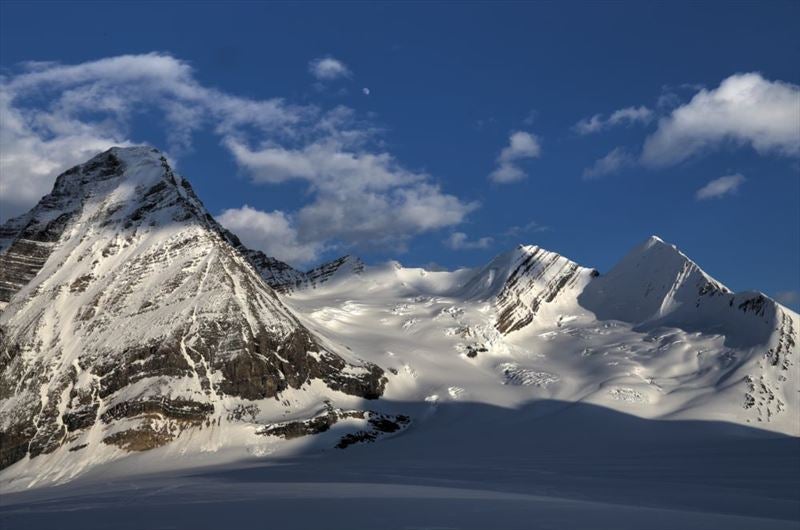
Serenity Mountain From Down Below

The Crew Sitting Around After Picking Up Our First Food Cache.

Fabulous morning light over Ghost Mountain

Approaching Mount Clemenceau with Tusk Peak On The Right.

Moonrise Over Tusk Peak

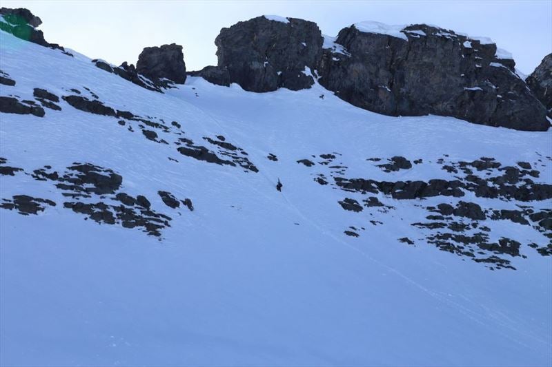
A Neat Terrain Feature to Ascend On Mount Clemenceau

Looking Towards Mount Columbia From The Summit of Mount Clemenceau
BenNearingburg is offline  
Quote
Sponsored Links
Advertisement
 
post #2 of (permalink) Old 05-24-2014, 01:40 PM
Headed for the Mountains
 
btrenholme's Avatar
 
Join Date: Jul 2008
Location: Vancouver, , .
Posts: 197
Default

WOW, what else can I say? Looking forward to the rest of the tale.
btrenholme is offline  
post #3 of (permalink) Old 05-25-2014, 06:37 AM
Off the Beaten Path
 
Zoran's Avatar
 
Join Date: Nov 2003
Location: Burnaby, BC, Canada.
Interest: Mountaineering;Bikepacking;Skiing
Posts: 584
Default

This is real wilderness. I love your report and pictures ...
Zoran is offline  
Sponsored Links
Advertisement
 
post #4 of (permalink) Old 05-25-2014, 06:41 AM
Off the Beaten Path
 
Zoran's Avatar
 
Join Date: Nov 2003
Location: Burnaby, BC, Canada.
Interest: Mountaineering;Bikepacking;Skiing
Posts: 584
Default

Could you please say hi to Liam? He is a very special guy and one of the strongest skiers I met in my life. Great personality!
Zoran is offline  
post #5 of (permalink) Old 05-25-2014, 11:11 AM
Headed for the Mountains
 
Join Date: Apr 2011
Location: Kamloops, B.C., Canada.
Posts: 220
Default

great report, awesome pictures
omegarun is offline  
post #6 of (permalink) Old 05-26-2014, 06:19 AM
High on the Mountain Top
 
Join Date: Dec 2008
Location: in da bush, alberta, Canada.
Interest: playing guitar,drums fly-fishing,hiking,scrambling,mountaineering
Posts: 1,072
Default

Nice!!

You have motivated me into possibly trying this next spring!!
Looking forward to reading about the central section!

Hopefully this thread isn't lost under a pile of planning threads and tr's of places visited and reported of many times over


nmcan84 is offline  
post #7 of (permalink) Old 05-26-2014, 08:02 AM
Headed for the Mountains
 
Join Date: Jun 2013
Location: Calgary, AB, Canada.
Posts: 164
Default

Awesome report! Can't wait to read the whole thing over my lunch break. Congrats on Clemenceau!
Matthew.Hobbs is offline  
post #8 of (permalink) Old 05-26-2014, 02:59 PM
High on the Mountain Top
 
vern.dewit's Avatar
 
Join Date: Mar 2008
Location: Calgary, Alberta, Canada.
Posts: 1,155
Default

Excellent TR and can't wait for the rest of it! Congrats on tackling some big terrain and bagging some beautiful peaks!
vern.dewit is offline  
post #9 of (permalink) Old 05-27-2014, 08:49 AM
Summit Master
 
LeeL's Avatar
 
Join Date: Mar 2005
Location: , , Canada.
Posts: 2,669
Default

That brought back memories - skied around Clemenceau back almost 7 8 years ago when the old Grassi hut still existed. Clemenceau to Columbia is also stunning but I'm sure that's on the list
LeeL is offline  
post #10 of (permalink) Old 05-27-2014, 12:39 PM Thread Starter
Hittin' the Trails
 
Join Date: May 2013
Location: Edmonton, Alberta, Canada.
Posts: 23
Default

Thanks for all the comments guys! Yeh it certainly was quite the trek. Just being out in the bush for that long, I'm almost surprised all of us didn't go a bit crazy (or maybe we did and I just couldn't tell ).

Quote:
quote:Could you please say hi to Liam? He is a very special guy and one of the strongest skiers I met in my life. Great personality!
Yeh Liam is a pretty crazy dude and he certainly was able to make downhill skiing with 70+lbs of gear seem effortless! I might end up meeting him and Jake down in Waterton when they eventually reach there as part of their 'walk from Jasper to Mexico' plan.

I'm just putting the finishing touches on the Central Section TR (merging panoramas takes a surprising amount of time), I'll toss up a link in this thread when its ready.
BenNearingburg is offline  
post #11 of (permalink) Old 05-29-2014, 09:09 AM Thread Starter
Hittin' the Trails
 
Join Date: May 2013
Location: Edmonton, Alberta, Canada.
Posts: 23
Default

Here is a trip report for the second part of the traverse (the Central section between Mount Clemenceau and the Columbia Icefield).

Summary For Central Section:
Full TR: http://benthereclimbedthat.ca/Outdoors/2014_GDT_Central
Trip Duration: 6 days from Mount Clemenceau to The Big Bend on HWY 93 (including one weather day)
Total Distance by GPS: 83 km
Ascended Peaks: Apex Peak and Chaba Peak

Trip Report In Very Brief:
We followed the route described in Chic Scott's book. Starting at Clemenceau heading to Apex Col - Eden Col - Chaba Col - Triad Col - Columbia Icefield - Saskatchewan Glacier - HWY 93

After all the ups and downs of the North section of the traverse being able to stick on (relatively) flat icefields was quite a refreshing change of pace (and made for very quick travel). The first day we descended from Clemenceau and up to Apex Col (sticking to the moraine on climbers left to avoid the very broken lower Apex Glacier). Apex Peak is a nice quick ascent just a stones-throw off the normal route and was well worth ascending (excellent summit views on a clear day). The second day we went from Apex Col to just below Chaba Col which is mostly straightforward glacier travel (amidst tons of nice looking peaks). The slope up to Eden Col is quite steep and ski crampons were essential with the hard snow conditions. Once at Eden Col keep as much speed as you can when descending to reach slopes beneath Chaba Peak. We took a detour from the traverse to ascend Chaba Peak, which while considerably longer than Apex is still worth heading up. We ascended the broad south face (threading between two bands of large crevasses) before cutting up climbers right to the ridge. The last few vertical meters are gained by traversing a corniced ridge. Excellent far reaching views from the summit! Heading back down Chaba we reached the top of the Chaba rappel. The rappel was technically straightforward but made awkward by heavy packs with skis attached to them (I ended up tipping over briefly loosing footing on a rock while having a very odd centre of mass). We camped a little ways below the bottom of the rap with great moonrise views of Columbia and King Edward. The next day we headed to the start of the 'backdoor' up onto the Columbia Icefield to the SE of Mount King Edward. Descending from Chaba to Snow Pass was quick and enjoyable, slogging up towards Triad Col less quick and a bit more arduous. We ended up following the guidebook coordinates and ascending the wrong slope to access King Edward (the easier line was 500m to the south). Once beneath King Edward it was a delicate matter of weaving through a minefield of crevasses to reach our campsite amidst a clump of trees below impressive glacier beneath Mount Columbia. Overnight there was sustained rain/sleet which softened up the snowpack enough that we couldn't ascend to the glacier until the following morning. The day after heading up to the Columbia was a nice change of pace (plenty of kickstepping/front pointing on hard icy snow/avalanche debris) to get back on glacier and then careful navigation. We suck climbers right to bypass many of the crevasses and eventually came across two big holes which required going even higher climbers right and traversing over avalanche debris to get around them. I ended up slipping over one of these and dangling over the crevasse (thankfully I was on belay with a solid anchor at the time). After getting on the Columbia it was a simple matter of heading across the trench to our camp and then descending to the road the morning after (there was half-hearted attempt on Mount Columbia on the last morning that was foiled by oncoming weather).

Looking back at Tusk Peak and Mount Clemenceau

The Crew Beneath Chaba Peak

Meghan On The Summit of Chaba Peak

Descending The Chaba Rap

Looking Up Towards Mount Columbia

From Camp Looking Towards Columbia At Sunset

Packing Up Before The Weather Moves In
BenNearingburg is offline  
post #12 of (permalink) Old 05-29-2014, 09:50 AM
High on the Mountain Top
 
Join Date: Jul 2009
Location: Calgary, Alberta, Canada.
Posts: 1,595
Default

Very impressive! What a character-building trip that must be.
Marko is offline  
post #13 of (permalink) Old 05-29-2014, 10:50 AM
Headed for the Mountains
 
Join Date: Jun 2013
Location: Vancouver, BC, Canada.
Posts: 150
Default

I'd be interested to hear how you made it up


Looks like a sketchy approach!
ryanisnan is offline  
post #14 of (permalink) Old 05-29-2014, 02:48 PM
Headed for the Mountains
 
Join Date: Jun 2013
Location: Calgary, AB, Canada.
Posts: 164
Default

Again, amazing photos from a remote area that not many will visit! Thanks for sharing/inspiring!
Matthew.Hobbs is offline  
post #15 of (permalink) Old 06-02-2014, 04:18 PM Thread Starter
Hittin' the Trails
 
Join Date: May 2013
Location: Edmonton, Alberta, Canada.
Posts: 23
Default

Quote:
quote:Originally posted by ryanisnan

I'd be interested to hear how you made it up
Looks like a sketchy approach!
Liam was in front and shovelled out some steps to give a bit of footing, the snow was pretty soft though so even when I was going up the 'steps' were slipping away (thankfully there was a bit of snow that was temporarily axe-able nearby!).
BenNearingburg is offline  
Reply

Thread Tools
Show Printable Version Show Printable Version
Email this Page Email this Page


Posting Rules  
You may not post new threads
You may not post replies
You may not post attachments
You may not edit your posts

BB code is On
Smilies are On
[IMG] code is On
HTML code is Off
Trackbacks are On
Pingbacks are On
Refbacks are On

 
For the best viewing experience please update your browser to Google Chrome
 

Search Engine Optimization by vBSEO 3.6.1