Burke Mountain Ski Area questions... - Page 3 - ClubTread Community

User Tag List

 2Likes
Reply
 
LinkBack Thread Tools
post #31 of (permalink) Old 12-24-2004, 11:41 PM
 
Join Date: Nov 2003
Posts: 1,647
Default

That's a good question scairns, how long the leases were for. Do they look much more than 50 years old? I can't remember. I know I'd be practically living up there if I had one! I wonder if the government bought back the leases when the ski hill went under.
BCer is offline  
Sponsored Links
Advertisement
 
post #32 of (permalink) Old 12-25-2004, 10:58 AM Thread Starter
Headed for the Mountains
 
Join Date: Dec 2004
Location: Port Coquitlam, B.C., Canada.
Interest: Hiking, Skiing, Trail Running, etc.
Posts: 285
Default

Judging by the interior of the cabins (flower wall paper, etc.) it looks 60's ish but thats before my time!
scairns is offline  
post #33 of (permalink) Old 02-13-2005, 06:32 PM
Headed for the Mountains
 
Join Date: Feb 2005
Location: , , .
Interest: Hiking
Posts: 101
Default

seeing if this works...
panic is offline  
Sponsored Links
Advertisement
 
post #34 of (permalink) Old 02-13-2005, 06:59 PM
Headed for the Mountains
 
Join Date: Feb 2005
Location: , , .
Interest: Hiking
Posts: 101
Default

What a fantastic web site and topic. I signed up right away.

Anyways... I have hiked most of burke and I got some questions that have been keeping me awake.
1. From the gun club to the woodlands walk loop; what is past that old moss covered bridge and how far does it go?
2. My dad's buddy says he used to fish up on the "then" un-breached dam of Monroe and stay in a cabin south east of the dam. He says it was open to the public to camp in. This was about 10-15 years ago. Is buddy on crack or is this real? please give details of location, cause south east is the slopes of monroe creek is it not?
3. From the quarry road trail head to monroe; dont go right and climb up to monroe, stay on the logging road and cross Deiner creek(careful in winter season). Stay south one minute and then west(hard to find)and continue up logging road. You will come across on your left some old quarry machines and trucks and sifter-things for rocks. what is this stuff? how long has it been there? why is it still there? continue on the logging road and it goes along the southern slopes and all of a sudden it turns into new blacktop that is in the middle of nowhere that is all covered in moss three inches thick. This road goes to a gun culb/range on the south slopes of burke about the 2.5km mark on quarry road. whats the story of the road and when was it last used? any info would be great.
4. Ive read there are old mines and shafts with rail track heading into them, where are they?

ive got lots of questions and lost of answers for others... this was wrote on feb. 13, 2005. please any replies would be great.
panic is offline  
post #35 of (permalink) Old 02-13-2005, 09:28 PM Thread Starter
Headed for the Mountains
 
Join Date: Dec 2004
Location: Port Coquitlam, B.C., Canada.
Interest: Hiking, Skiing, Trail Running, etc.
Posts: 285
Default

Burke definately is an intersting area that has fasinated me for years...

To answer your question to the best of my ability:

l.) I havnt been that far up woodland walk (a friend of mine almost collaps from exahustion and we had to return, apparently he was in worse shape then we thought...) but I would have to assume it continues directly into the coquitlam watershed and joins one of their many service roads (illegal to hike in without a permit.)

2.) According to the bc parks website, there are no official public cabins/shelters (http://wlapwww.gov.bc.ca/bcparks/exp...s/pinecone.htm) but this may be left from before the area was made into a park in the 80's... I would assume if the cabin is even there, that it would not be usable...

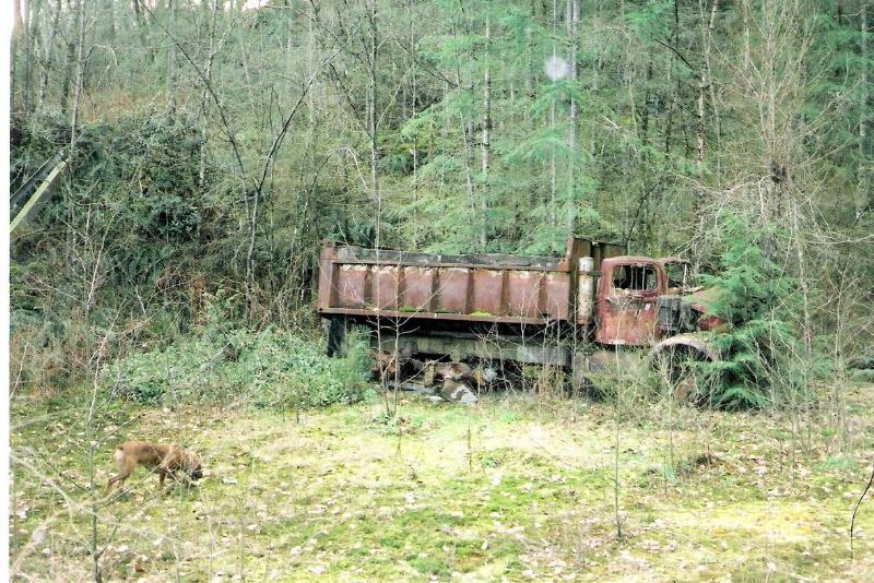
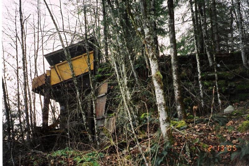
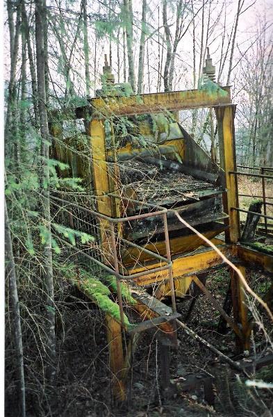
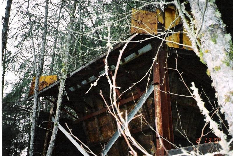
3.) I would love to have found that... but I dont understand... the road to the gun club isn't paved! its only an old gravel hydro/ski access road... I guess you dont have any pictures handy of the road or equipment, do you?
But I guess its possible that the road was used to connect either the ski village or a primative quarry, which would explain the equipment... but I dont know...

4.) I have heard of minning in the area, but have yet to have seen any signs of it... but, the bc parks website says:
"An abandoned mine tunnel and old steam donkey west of Pitt Lake are evidence of resource use in the area."
Unfortuanely, that description is little help in locating a mine shaft along the huge lake, in isolated wilderness... but if anybody had more info on that, I would love to hear it!!


I hope my info is accurate, but I may be wrong...

Any other questions, or especially info you have on the area, I would love to hear it, as I am very interested in this isolated wilderness that is only minutes from our backyards!
scairns is offline  
post #36 of (permalink) Old 02-13-2005, 10:43 PM
Headed for the Mountains
 
Join Date: Feb 2005
Location: , , .
Interest: Hiking
Posts: 101
Default

Scairns whats up buddy...

thanks for the info.

I agree with you that the woodlands walk trail extends into the watershed and axcess is not permited. the reason i asked is because of the extent of old growth stumps of-i guess red cedar, and alpine fir. some of them on the "lower woodlands walk trail loop are just massive and they are everywhere-just fantastic. sad there gone though...you should check it out, easy walk 'bout 3.5 hours return.

the cabin at munro might be toast but that interests me because buddy said that he would maintain it for months on end(kind of a sketchy source).

Okay Scairns... this ones for you, my details of the trail were sparce to say the least-just cause it is detailed and very spooky. when i found this i all most pooped myself. i found it once with my ex girlfriend and then couldnt find it for years after, really. Take quarry road north east past minnekhada to the munro trail head. not harper. the trail starts on an old logging or road and heads west uphill. There is a trail turn off on the right that is flagged red and heads up to munro lake or the village. dont take this keep striaght. go to you hit a big creek or river.this is Deiner creek. Cross the creek-easy now hard after heavy rains, ONE THING... south of the crossing on the creek is very dangerous holes in the rock and steep falls, watch if you have a dog or one of my friends. head south after the cross only 30 seconds to a min untill you hit a bluff and continue to head west along the logging road. easy to find if you just picture where the road should be, as it wraps around the hill after the creek. this is the hardest part to find the trail, unmarked ofcourse. continue along the road 10 mins. until a building is seen off on the left or south. very cool and very weird. the is a bluff and on this bluff and it was most likely used for a quarry. things i have seen up there that are: big two story open framed building, trailer from an old truck, an old dump truck 1950-60ish conveyer belts 50 feet long, old industrial fittings, piping, rock sorting buildings thingies, all sorts of fantastic stuff. very cool sorry no picutres yet i go up burke all the time i get some and post them. if you contine on the road it gets deeper into the woods along the south eastern slope about 200 m mark. from here i noticed that the road widend and under thick moss and veg there was black top-very weird. this contined until i popped out at a old rirle range -might still be in use not sure. carefull on the road for deep holes of underground springs and rivers. there is a hole in the middle of the road, bout 10 feet deep -fall in there scairns, we wont be talking and ill feel bad-i guess that is why this road isnt on many maps.

worth the trip, i post pictres...

oh ya.. exits at about where the power lines bisect quarry road south of the munro trailhead.
panic is offline  
post #37 of (permalink) Old 02-13-2005, 11:40 PM
Headed for the Mountains
 
Join Date: Feb 2005
Location: , , .
Interest: Hiking
Posts: 101
Default

Scairns, more questions for you and all:

1. where, can i find old growth on burke, not just graveyards of stumps?
2. i read in the local rag that the was a old logging dump on the west side of pitt river that was very close to the water's edge. during recent rains and floods the dump was breached and has been dumping crap into pitt lake for km's. i read that the "near by trees looked like christmas trees from far because they had so much crap hanging off them." any info would be great.
3. info on old maps of the area, logging, skiing, cross country.
4. any campsites on burke at all? dont think so.unmaintained?
5. drive up coast meridian, right on harper, going east-hit the switch back now going north a gated road on the right called Conifer. were does this go? ive seen campers and rv in there. what is it?
panic is offline  
post #38 of (permalink) Old 02-14-2005, 10:46 AM
 
Join Date: Nov 2004
Posts: 21
Default

The munro lake trail head is a deacticvated logging road. At one point there was likely a bridge over deier creek. For many years that area has been used as a rock quarry. Munro lake was dammed to provide water for the quarry. Once exhausted the dam was removed. Most of Burke was logged at the turn of the last century. There is some old growth left around the Munro lake area. Likely the machinery you have found was part of logging or mining in the last 50 60 years. why companies would leave machinery behind?. Your guess as good as mine. On the north side of quarry road you'll note there are about 6 homes set back from the road. I would wonder if the rifle range you found belongs to one of these people, as the road you mentioned likely just bypasses some of these properties. The end of conifer dr has one house with a miserable owner. I 've been up there several times . really a bit of a mess. There is a trail head that starts at the end of the road but I've never followed it. If i would gues I would say it connects with the galloway trail. In about 1985 I was part of a boy scout troop or pack or whatever. We did a survival camp up at the ned of Edwards st. If you go along Victoria dr you climb up the hill and then it starts going steply sownward toward Minekhadda. Halfway down the hill on the left is edwards. Anyway we hike quite a ways up the road until we got to a relatively flat section and set up camp. I have never been back ther but I suspect we were very close to the power line trail. I'd like to go back there but I'm not sure if its private propertiy or not. There are no marked campgrounds anywhere on Burke. It is a provincial park, you are permitted to camp there. Regular camping etiquette applies. As well licensed vehicles are permitted on the main roads. Burke is one of those really eery kind of alluring places. I've been going there for the last 20 years and find something new every time.

Steve
stemotor is offline  
post #39 of (permalink) Old 02-14-2005, 12:29 PM
 
Join Date: Nov 2003
Posts: 1,647
Default

Hi panic, here's an article on the Pitt River garbage which you might have already read?:
http://www.tricitynews.com/portals-c...d=370568&more=

and another thread on the topic:
https://www.clubtread.com/sforum/topi...,river,garbage

A few months ago we were up at Munro Lk. and one of the guys looked to the south-east shore and thought for sure he'd been there before and that there was a cabin, like an A frame or something. In another thread here someone mentioned it as well so there's got to be something there...
BCer is offline  
post #40 of (permalink) Old 02-14-2005, 03:02 PM Thread Starter
Headed for the Mountains
 
Join Date: Dec 2004
Location: Port Coquitlam, B.C., Canada.
Interest: Hiking, Skiing, Trail Running, etc.
Posts: 285
Default

As for old maps, there is a map by the Burke mt. Naturalist on page 1 of this topic...

For skiing, ect. the park officially is a cross-country and snowshoing destination using primarilly the existing trails, most of the orginal ski runs are ski-able as well as some of the clear cutting makes good runs...
scairns is offline  
post #41 of (permalink) Old 02-14-2005, 07:00 PM
Headed for the Mountains
 
Join Date: Feb 2005
Location: , , .
Interest: Hiking
Posts: 101
Default

seeing if this works
panic is offline  
post #42 of (permalink) Old 02-14-2005, 07:15 PM
Headed for the Mountains
 
Join Date: Feb 2005
Location: , , .
Interest: Hiking
Posts: 101
Default

hey guys thanks so much for the info and response. i decided to go up to the trail as i talked about before. these are some pictures of the stuff i mentioned and i hope people can give me info about why it is still there and the story behind it. my dog can be used to judge scale(100lbs mastiff).
panic is offline  
post #43 of (permalink) Old 02-14-2005, 07:19 PM
Headed for the Mountains
 
Join Date: Feb 2005
Location: , , .
Interest: Hiking
Posts: 101
Default

the dog is in all the pictures above...look at the size of this stuff...very industrial.
panic is offline  
post #44 of (permalink) Old 02-14-2005, 07:20 PM
Headed for the Mountains
 
Join Date: Feb 2005
Location: , , .
Interest: Hiking
Posts: 101
Default

panic is offline  
post #45 of (permalink) Old 02-14-2005, 07:33 PM
Headed for the Mountains
 
Join Date: Feb 2005
Location: , , .
Interest: Hiking
Posts: 101
Default

panic is offline  
Reply

Thread Tools
Show Printable Version Show Printable Version
Email this Page Email this Page


Posting Rules  
You may not post new threads
You may not post replies
You may not post attachments
You may not edit your posts

BB code is On
Smilies are On
[IMG] code is On
HTML code is Off
Trackbacks are On
Pingbacks are On
Refbacks are On

 
For the best viewing experience please update your browser to Google Chrome
 

Search Engine Optimization by vBSEO 3.6.1