Michelle Lakes - ClubTread Community

User Tag List

 
LinkBack Thread Tools
post #1 of (permalink) Old 08-28-2007, 10:06 PM Thread Starter
Off the Beaten Path
 
Join Date: Mar 2007
Location: AB, Canada.
Posts: 940
Default Michelle Lakes

My sister and I went for a weekend hiking trip to Michelle Lakes near Saskatchewan Crossing. This was her first hiking attempt since recovering from a reactive arthritis in her lower joints due to a bad case of dysentery overseas... tough kid. Elevation gain was just over 1000m; from 1400m to 2480m.

Here is a topographic map of the area: http://www.box.net/shared/vqcc35doy8

The trailhead was difficult to find at first; there is no sign for Owen Creek, despite it being one of the largest creeks in the area. Heading west on the David Thompson Highway, just prior to the Banff Park signage, we found a small trail leading down to the right into a secluded parking area beside the unmarked bridge which crossed Owen Creek. Here we found a crude sign that marked the trailhead.

We followed the trail up the creek, and before we knew it, began climbing beside a spectacular canyon, so narrow at points that you could literally walk across the top while the creek coursed far below your feet.


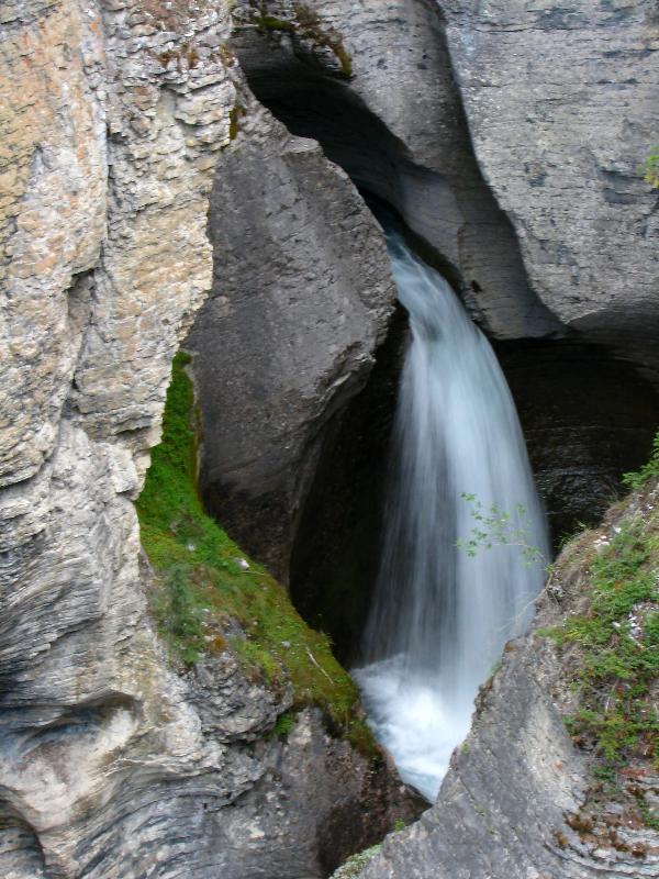
When the stream flattened out, it was just as beautiful as it channeled through moss-covered rocks.


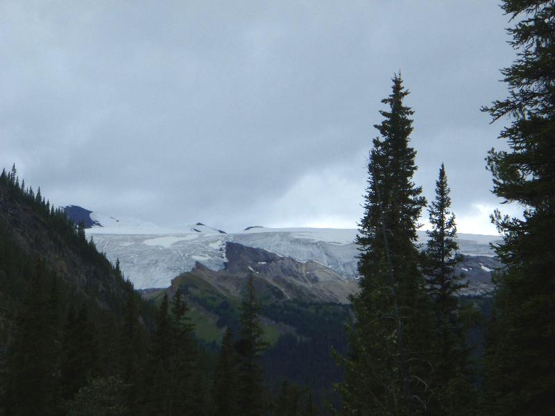
As the stream turned west and the valley widened, we soon had difficulty staying on a good trail. We would follow a path for a short time, before losing it and picking it up a little further on. Still, it was relatively easy going. We met two other hikers and were happy for the company and safety of two more people. The magnificent Wilson Icefield to the northwest came into view during this part of the trail.


When the valley turned north again, towards Michelle Lakes, we soon found ourselves without a trail, and realized it was easier to rock-hop up the valley than keep to the edges, since the shoulders were so steep. We ended up temporarily losing the other two hikers when they stopped for lunch.


We happened upon a very good camp spot on the left side of the creek at a pretty good elevation gain, and decided to pitch our tent and hang our food. This turned out to be a good idea since the weather soured very shortly thereafter.

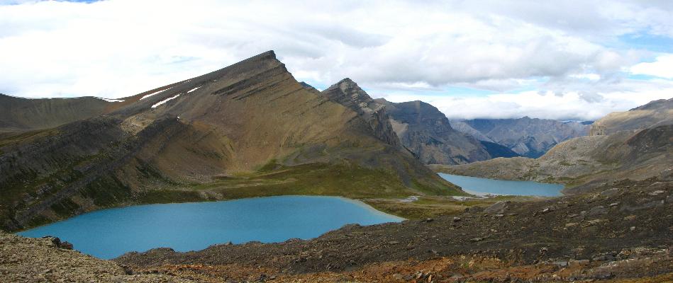
We carried on without packs in the rain, and at the edge of the treeline, met up with the other two who we had separated from, who were debating whether or not to continue to the pass. It was decided that they would leave their packs and head up with us. There was a strong headwind, and the rain showed no sign of slowing as we trudged up the rocky pass. Luckily, we found the top of the pass to be relatively sheltered, and the view was magnificent. Through the sleet, we could see the two alpine lakes perched against a mountain backdrop. And by some stroke of luck, the clouds broke for just a few minutes for us to capture some excellent photos.


Cool rock!

There were a few curious marmots that seemed to enjoy posing for our cameras.


We lingered just a little while before heading back, since we were fairly thirsty, wet, and cold by this point. We got more rain overnight, and woke to a slightly damp tent (forgot to cinch up the fly at the foot of the tent). It was tougher on the way down because all the rocks were wet and slippery. Each of us took a couple spills, thankfully none major. We made better time for a while by climbing way up into the trees to the east. Once in the main valley, the descent became much easier and the rain relented somewhat. We nearly stepped on a young rock ptarmigan (?) while its mother kept watch in a nearby tree.


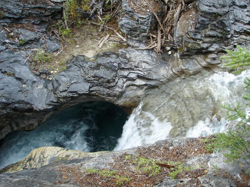
The Owen Creek canyon was every bit as interesting on the way down, and we stopped for several more pictures.


It was an excellent 2 day backpack or long day hike, but probably best done as a 3 day trip to allow a full day of exploration at the top. We would have liked to see the falls below the lower lake, but based on the topo map, I'm skeptical about how much we could have seen from on top.
dav1481 is offline  
Quote
Sponsored Links
Advertisement
 
post #2 of (permalink) Old 08-28-2007, 10:34 PM
Super Moderator
 
KARVITK's Avatar
 
Join Date: Apr 2005
Location: Abbotsford, B.C., Canada.
Interest: Hiking, Snowshoeing, and Photography. Enjoying the outdoors fresh air and fitness experience.
Posts: 17,917
Default

Quote:
quote:Originally posted by dav1481


Cool rock!
That is quite a rock, like a petrified marmot ..

K
KARVITK is offline  
post #3 of (permalink) Old 08-29-2007, 07:00 AM
Summit Master
 
Join Date: Aug 2003
Location: Finally stopping that crazy suffering that is ice, climbing to concentrate on great ski tours!, .
Interest: Anything that can drag me to the mountains. Backpacking is #1, followed by climbing, dayhiking and camping with family.
Posts: 3,782
Default

Any heli-hikers? A few years ago I was backpacking the glacier trail and began at Owen Gorge. I had an eleven day load of food/fuel and had stuggled up to the Michelle Lakes/Unnamed Pass area and found some folks in cotton tees and runners having lunch and looking anything other than pooped out. They had arrived by helicopter!

It's a great area that see little traffic otherwise, which is nice.

Last week we spent a few days in the Landslide Lake/Lake-of-the-Falls area, and the ethic of Leave No Trace is NOT being practiced there. Gross.
johngenx is offline  
Sponsored Links
Advertisement
 
post #4 of (permalink) Old 08-29-2007, 07:51 AM
Summit Master
 
Join Date: Jan 2005
Location: , , Canada.
Interest: Hiking, hunting, fishing, and many others.
Posts: 3,951
Default

Looks like a grand place to go. Beautiful in there and quite the gorge.
That in itself looks like a worth while trip. [8D]
Wildman is offline  
post #5 of (permalink) Old 08-29-2007, 08:15 AM Thread Starter
Off the Beaten Path
 
Join Date: Mar 2007
Location: AB, Canada.
Posts: 940
Default

Quote:
quote:Originally posted by johngenx

Any heli-hikers? A few years ago I was backpacking the glacier trail and began at Owen Gorge. I had an eleven day load of food/fuel and had stuggled up to the Michelle Lakes/Unnamed Pass area and found some folks in cotton tees and runners having lunch and looking anything other than pooped out. They had arrived by helicopter!

It's a great area that see little traffic otherwise, which is nice.

Last week we spent a few days in the Landslide Lake/Lake-of-the-Falls area, and the ethic of Leave No Trace is NOT being practiced there. Gross.
Yes, it was a little defeating to reach the lakes through the wind and rain after several hours, only to find 3 other people happily fishing in the lower lake!

Too bad about Landslide and Lake of the Falls. I'm happy to report we found the area absolutely pristine, although we didn't go right down to the lakes themselves. We could only find a couple places where people had camped, and they were very considerate in leaving no trace.
dav1481 is offline  
post #6 of (permalink) Old 09-03-2007, 08:31 AM
Headed for the Mountains
 
Join Date: Feb 2006
Location: Lethbridge
Posts: 221
Default

We did a 6 day backpack going into Landslide lake down to the Cline river,up Waterfalls creek into the Michelle lakes and down Owen creek. One of the coolest trip I've done. The alplands at the head of Waterfalls creek are incredible. Why this entire area is not protected in Banff national park or the Whitegoat wilderness is beyond me. Helicopters should not be allowed to land anywhere near the Michelle lakes.
gunthur is offline  
post #7 of (permalink) Old 09-03-2007, 03:24 PM
Summit Master
 
Join Date: Jul 2003
Location: PNW
Posts: 8,493
Default

Nice area.Love those lake shots.That rock looks like a giant Dinosaur tooth that needed attention
Aqua Terra is offline  
post #8 of (permalink) Old 09-03-2007, 09:59 PM
Hittin' the Trails
 
Join Date: Jun 2004
Location: Vancouver, BC, Canada.
Interest: Trail-blazing, route-finding, peak-bagging, and wilderness wandering of any sort.
Posts: 48
Default

Awesome. Thanks for the update and revisit to that beautiful and remote area. I hiked up amazing Owen Creek last summer and continued on past Michele Lakes to Pinto Lake... and was blessed with blue-sky happiness. [8D]

This photo is from the trail/route above Waterfalls Creek. The unnamed pass (2590m) just to the north of Michele Lakes is in the background.


BRAD
bradv98 is offline  
post #9 of (permalink) Old 09-11-2007, 12:08 AM
Summit Master
 
Join Date: Sep 2003
Location: Da\'Wack, BC, Canada.
Interest: Hiking, flyfishing, camping, photography, kayaking, swimming, x-country skiing wana get my open water dive certification... scrabble, mean yatzee player.........
Posts: 5,392
Default

Very nice. I've been considering exploring some of the unique alpine and valleys in this area in the future.

The lakes are beautiful.

Thanks for posting your report.
exscape is offline  
post #10 of (permalink) Old 09-12-2007, 08:53 PM
Summit Master
 
Join Date: Feb 2004
Location: , , USA.
Interest: Hiking, photography,
Posts: 3,988
Default

What an amazing place! My kind of terrain! Too bad about the falls and slips in the slick rocks. Way to go for your sister! Dysentery was so common where I lived in Africa as a kid, that we jokingly named it after the nearby city of Asmara. "Asmaritis" I even got hepatitis whilst living there. Now, I can't give blood.
What causes all that uplifting and anticlines sp?
Your pictures are amazing! Rock formations are radical and colorful.
Looks like a perfect summertime destination! thanks!
Rented Mule is offline  
post #11 of (permalink) Old 09-14-2007, 04:48 PM Thread Starter
Off the Beaten Path
 
Join Date: Mar 2007
Location: AB, Canada.
Posts: 940
Default

Quote:
quote:Originally posted by Rented Mule

What causes all that uplifting and anticlines sp?
Your pictures are amazing! Rock formations are radical and colorful.
Thanks; from what I understand, this type of uplifting and stratification is characteristic of the eastern Rockies and frontranges which were on the tail end of the tectonic "push." That whole area of Alberta was a tropical sea at one point, and there remains a lot of plant and animal evidence, in both oil and fossil form. There is a creek called Coral Creek, which (I think I read somewhere) was named because of the evidence of coral life found in the valley. But I'm far from a geologist...
dav1481 is offline  
post #12 of (permalink) Old 06-28-2010, 08:25 AM
Hittin' the Trails
 
Join Date: Jun 2010
Location: Lacombe, Alberta, Canada.
Posts: 8
Default

hey dave, thanks for this post - i'm looking forward to getting out to those lakes sometime this summer.

unfortunately this area should be more protected - right across to the other side of the front ranges, as people are certainly leaving an impact. the constant helicopter flights out of the david thompson resort up the cline river certainly have an effect on local wildlife.

incorporating this area in the whitegoat wilderness would, however, only reduce trail maintenance. alberta forestry and sustainable resource development needs to organize some kind of governing body to protect these areas - but what government gives out funding for those projects in this day and age?

in the meantime i'll just keep packing other people's garbage out!
touristiko is offline  
Reply

Thread Tools
Show Printable Version Show Printable Version
Email this Page Email this Page


Posting Rules  
You may not post new threads
You may not post replies
You may not post attachments
You may not edit your posts

BB code is On
Smilies are On
[IMG] code is On
HTML code is Off
Trackbacks are On
Pingbacks are On
Refbacks are On

 
For the best viewing experience please update your browser to Google Chrome
 

Search Engine Optimization by vBSEO 3.6.1