Hesquiat Peninsula - a few notes and some tips - ClubTread Community

User Tag List

 
LinkBack Thread Tools
post #1 of (permalink) Old 09-23-2014, 07:45 PM Thread Starter
Hittin' the Trails
 
Join Date: Sep 2014
Location: Vancouver, BC, Canada.
Posts: 5
Default Hesquiat Peninsula - a few notes and some tips

Three of us did the Hesquiat Peninsula in August 2014 and thought I'd share a few notes. I found other people's TRs really useful when planning this one so here's my contribution to the body of knowledge.

We camped at the Gold River campground the night before and headed to Air Nootka in the morning to start the trip proper. We got dropped off at Escalante Point at 10:00am, camped day 1 at Barcester Bay, day 2 at (just north of) Homais Cove, day 3 at Matlahaw Point and day 4 (just north of) Le Claire Point. The final (5th) day is short and allows plenty of time for checking out Cougar Annie's Garden before an afternoon pick up from the lake. There are of course other options there but that plan worked well for us. It's an exposed bit of coastline, until you enter Boat Basin so if the weather turns crappy it might be nice to have a spare day to sit it out. We were lucky and had great weather the whole way except for a little atmospheric mist here and there. I did Nootka Trail in 2013 and I'd say Hesquiat is similar but a little more rugged. There's no elevation change to speak of and I did it in trail running shoes, no problem. I really enjoyed this hike. It feels remote, there are very few people, there are some beautiful beaches, bays and views. The only bummer is the pungent rotting seaweed that you squelch through at low tide in a few spots, but that's all part of the coastal experience!

Escalante Point:


Barcester Bay:


Tidal Shelf formations - lots of this kind of stuff along the way:


More below...
jonmep is offline  
Quote
Sponsored Links
Advertisement
 
post #2 of (permalink) Old 09-23-2014, 07:52 PM Thread Starter
Hittin' the Trails
 
Join Date: Sep 2014
Location: Vancouver, BC, Canada.
Posts: 5
Default

Camping just north of Homais Cove, by the creek. Cool but slightly tense moment as a bear wanders past while we're eating dinner, so there's load of great smelling food out!


Estevan lighthouse:


Matlahaw Point:


That atmospheric mist I was talking about:


After Billion Boulder Beach the pay off, beautiful white sandy bay between Antons Spit and Le Claire Point:


...
jonmep is offline  
post #3 of (permalink) Old 09-23-2014, 08:00 PM Thread Starter
Hittin' the Trails
 
Join Date: Sep 2014
Location: Vancouver, BC, Canada.
Posts: 5
Default

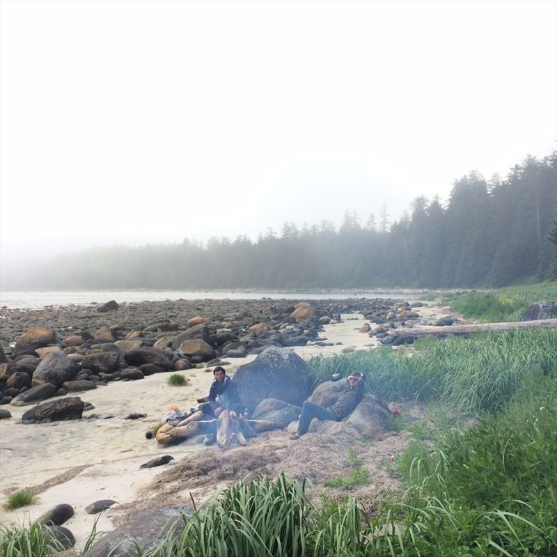
Awesome camping spot just north of Le Claire Point:


And how my buddies decided to camp there in their Hennessy hammocks:


And I'll leave you with a few tips:
The (otherwise excellent) John Baldwin map says there is water at Smokehouse Bay (Matlahaw Point) in the forest, but as someone else here has noted, it should not be relied on. We were here August 2nd and there was a bit of ground that felt a bit squishy, but that was it. Maybe in the spring it's ok but I wouldn't bank on it. We passed a group (going CW) who were expecting to find water there - that could have been a miserable trek to the nearest water source for them had we not clued them in.

At the camping spot just north of Le Claire Point there is a wide creek. Wade up the creek for ten minutes or so and there is a really cool waterfall. Worth a bit of wading if it's not cold when you're there.

On this bit of coast the wind really picks up in the afternoons so Air Nootka recommend you arrange to get dropped off at Escalante in the morning. Worth factoring that in when you're planning your trip. The pickup point in the lake at Boat Basin is sheltered so it's not a factor. This is one good reason to do the trail CCW.

Finally, I would highly recommend reading the book 'Cougar Annie's Garden' by Margaret Horsfield before you do the trail. It contains so much history about the whole peninsula that it will really add to your enjoyment of the hike - you will be able to spot the little clues from the past dotted about the peninsula that you wouldn't notice otherwise, and you'll understand the significance and names of the various bays and points. Also you'll be able to impress your friends with your knowledge I read it when I got back and was kicking myself for not reading it beforehand. It's actually a really interesting account of that period in general. Thoroughly enjoyable read. (I have no affiliation with the author or whatever).

jonmep is offline  
Sponsored Links
Advertisement
 
post #4 of (permalink) Old 09-23-2014, 11:31 PM
Headed for the Mountains
 
Join Date: Aug 2010
Location: Squamish, BC, Canada.
Posts: 360
Default

Great TR. Thanks for the info. It's on my list and this will be very useful when I do get there.
seboyle is offline  
post #5 of (permalink) Old 09-24-2014, 12:16 PM
High on the Mountain Top
 
Join Date: Aug 2002
Location: Whooville
Interest: Love the outdoors. Trying new things. And at night......BOGGLE!
Posts: 1,821
Default

Awesome! Thanks so much for the useful information!
calixtomoon is offline  
post #6 of (permalink) Old 09-24-2014, 07:20 PM
High on the Mountain Top
 
Join Date: Jul 2006
Location: Burnaby, , .
Posts: 2,221
Default

Thanks for posting and bringing back some great memories.
burnabyhiker is offline  
post #7 of (permalink) Old 04-19-2015, 12:57 AM
Hittin' the Trails
 
Join Date: Sep 2006
Location: east coombs, , .
Interest: camping,fishing,hiking,conoeing,the great outdoors.
Posts: 35
Default

Thanks. good info
davebambrough is offline  
post #8 of (permalink) Old 04-25-2015, 01:36 PM
Headed for the Mountains
 
Join Date: Aug 2008
Location: Calgary, Alberta, Canada.
Interest: Hiking, diving, snowshoeing, kayaking
Posts: 324
Default

Nice summary. The more I look back, the more it would have been better to take an extra day and explore around Escalente before heading south. Oh well - next time. Happy Trails
Bluefoot is offline  
post #9 of (permalink) Old 06-07-2015, 01:22 PM
Headed for the Mountains
 
Join Date: Apr 2010
Location: Calgary, , .
Posts: 180
Default

Quote:
Originally Posted by jonmep View Post
I did Nootka Trail in 2013 and I'd say Hesquiat is similar but a little more rugged.
Did you take food caches to store your food overnight on Nootka, or did you find that there was actually opportunity to hang food? I just got a food cache as a few of us are doing Nootka next month. Would really prefer to hang, but reluctant to go that way until I get good evidence of what the options are :-).
BarbaraB is offline  
post #10 of (permalink) Old 06-20-2015, 01:36 PM Thread Starter
Hittin' the Trails
 
Join Date: Sep 2014
Location: Vancouver, BC, Canada.
Posts: 5
Default

Quote:
Originally Posted by BarbaraB View Post
Did you take food caches to store your food overnight on Nootka, or did you find that there was actually opportunity to hang food? I just got a food cache as a few of us are doing Nootka next month. Would really prefer to hang, but reluctant to go that way until I get good evidence of what the options are :-).
We were able to hang our food every night without problems. Some of the trees were a bit spindly and a couple of times we had to walk for a few minutes from the camp site to find a decent hanging spot but we always found something. This applies to Nootka and Hesquiat. Going to do an Olympic Peninsula (WA) trip next month and I believe a food cache is required by law there. Never carried one before but it looks a bit awkward to carry and adds a bit of weight.

Have fun, it's a beautiful hike.
jonmep is offline  
Reply

Thread Tools
Show Printable Version Show Printable Version
Email this Page Email this Page


Posting Rules  
You may not post new threads
You may not post replies
You may not post attachments
You may not edit your posts

BB code is On
Smilies are On
[IMG] code is On
HTML code is Off
Trackbacks are On
Pingbacks are On
Refbacks are On

 
For the best viewing experience please update your browser to Google Chrome
 

Search Engine Optimization by vBSEO 3.6.1